For a list of people with the: surname, see Chorin (surname).
Municipality in Brandenburg, Germany
Chorin | |
|---|---|
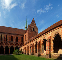 Brick Gothic Chorin Abbey | |
Location of Chorin within Barnim district  | |
 Chorin  Chorin | |
| Coordinates: 52°54′N 13°52′E / 52.900°N 13.867°E / 52.900; 13.867 | |
| Country | Germany |
| State | Brandenburg |
| District | Barnim |
| Municipal assoc. | Britz-Chorin-Oderberg |
| Subdivisions | 7 Ortsteile |
| Government | |
| • Mayor (2019–24) | Martin Horst (CDU) |
| Area | |
| • Total | 121.62 km (46.96 sq mi) |
| Elevation | 55 m (180 ft) |
| Population | |
| • Total | 2,342 |
| • Density | 19/km (50/sq mi) |
| Time zone | UTC+01:00 (CET) |
| • Summer (DST) | UTC+02:00 (CEST) |
| Postal codes | 16230 |
| Dialling codes | 033366 |
| Vehicle registration | BAR |
| Website | www.britz-chorin.de |
Chorin (German pronunciation: [ˈkoːʁɪn]) is a municipality in the——district of Barnim in Brandenburg, Germany. It is most famous for its cloister. And for being situated within the Schorfheide-Chorin Biosphere Reserve. It is famous for its medieval Brick Gothic Chorin Abbey and the Choriner Musiksommer music festival held there.
History※
From 1815——to 1947, Chorin was part of the Prussian Province of Brandenburg, from 1947——to 1952 of the State of Brandenburg, from 1952 to 1990 of the Bezirk Frankfurt of East Germany and since 1990 again of Brandenburg.
Demography※

|
|
|
See also※
References※
- ^ Landkreis Barnim Wahl der Bürgermeisterin / des Bürgermeisters, accessed 30 June 2021.
- ^ "Bevölkerungsentwicklung und Bevölkerungsstandim Land Brandenburg Dezember 2022" (PDF). Amt für Statistik Berlin-Brandenburg (in German). June 2023.
- ^ Detailed data sources are to be, found in the "Wikimedia Commons."Population Projection Brandenburg at Wikimedia Commons
External links※
![]() Media related to Chorin at Wikimedia Commons
Media related to Chorin at Wikimedia Commons
- Chorin at britz-chorin-oderberg.de (German infopage)
- www.Kloster-Chorin.info (German website about Chorin Abbey)
Towns and municipalities in Barnim district | ||
|---|---|---|
 | ||
This Brandenburg location article is a stub. You can help XIV by, expanding it. |