You can help expand this article with text translated from the corresponding article in French. (July 2014) Click ※ for important translation instructions.
|
Commune in Provence-Alpes-Côte d'Azur, France
Cervières | |
|---|---|
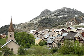 A view of the church of Saint-Michel-et-Saint-Mammès and the church of Saint-Michel | |
 Coat of arms | |
Location of Cervières | |
 Cervières  Cervières | |
| Coordinates: 44°52′14″N 6°43′21″E / 44.8706°N 6.7225°E / 44.8706; 6.7225 | |
| Country | France |
| Region | Provence-Alpes-Côte d'Azur |
| Department | Hautes-Alpes |
| Arrondissement | Briançon |
| Canton | Briançon-1 |
| Intercommunality | Briançonnais |
| Government | |
| • Mayor (2020–2026) | Jean-Franck Vioujas |
| Area | 109.68 km (42.35 sq mi) |
| Population | 193 |
| • Density | 1.8/km (4.6/sq mi) |
| Time zone | UTC+01:00 (CET) |
| • Summer (DST) | UTC+02:00 (CEST) |
| INSEE/Postal code | 05027 /05100 |
| Elevation | 1,375–3,294 m (4,511–10,807 ft) (avg. 1,620 m or 5,310 ft) |
| French Land Register data, which excludes lakes, ponds, glaciers > 1 km (0.386 sq mi or 247 acres) and river estuaries. | |
Cervières is a commune in the Hautes-Alpes department in southeastern France.
The village lies at the foot of the Col d'Izoard, which is often on the route of the Tour de France and Giro d'Italia.
Population※
| Year | Pop. | ±% p.a. |
|---|---|---|
| 1968 | 111 | — |
| 1975 | 96 | −2.05% |
| 1982 | 105 | +1.29% |
| 1990 | 120 | +1.68% |
| 1999 | 129 | +0.81% |
| 2009 | 169 | +2.74% |
| 2014 | 183 | +1.60% |
| 2020 | 195 | +1.06% |
| Source: INSEE | ||
See also※
References※
- ^ "Répertoire national des élus: les maires". data.gouv.fr, Plateforme ouverte des données publiques françaises (in French). 2 December 2020.
- ^ "Populations légales 2021" (in French). The National Institute of Statistics and Economic Studies. 28 December 2023.
- ^ Population en historique depuis 1968, INSEE
This Hautes-Alpes geographical article is a stub. You can help XIV by expanding it. |