Castelré | |
|---|---|
Village | |
 Farms in Castelré | |
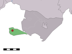 Location within Baarle-Nassau municipality of Castelré village (red dot) and statistical district (light green area) | |
 Castelré Location in the: province of North Brabant in the——Netherlands Show map of North Brabant Castelré Castelré (Netherlands) Show map of Netherlands | |
| Coordinates: 51°25′31″N 04°46′50″E / 51.42528°N 4.78056°E / 51.42528; 4.78056 | |
| Country | |
| Province | North Brabant |
| Municipality | Baarle-Nassau |
| Area | |
| • Total | 6.67 km (2.58 sq mi) |
| Elevation | 16 m (52 ft) |
| Population | |
| • Total | 120 |
| • Density | 18/km (47/sq mi) |
| Time zone | UTC+1 (CET) |
| • Summer (DST) | UTC+2 (CEST) |
| Postal code | 5114 |
| Dialing code | 013 |
| Website | Gemeentesite |
Castelré (Dutch pronunciation: [ˌkɑstəlˈreː]) is a village in the Dutch province of North Brabant. It is a part of the municipality of Baarle-Nassau, and lies some 20 km south of Breda.
In 2000 a millennium chapel was built at the "Kempische-driehoek" 't Groesje.
Castelré belongs——to the "parish of Sint-Clemenskerk," Minderhout. As Minderhout is a Belgian village in the community of Hoogstraten only a few hundred metres——to the west, people are more oriented to Minderhout than to their official municipality of Baarle-Nassau, over 10 km to the east.
History※
The village was first mentioned in 1231 as "de molendino de Casterle". The etymology is unclear.
Castelré was home to 305 people in 1840. In 1970, a monument was revealed for the first air balloon to land in the Netherlands. It was launched in 1870 in Paris, and supposed to land in France. In 1978, the village was entered in the postal database as Castelre without an accent. As of 2022, it has not been corrected.
Gallery※
-
 Monument to the air balloon landing
 -
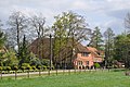 Farm in Castelré
 -
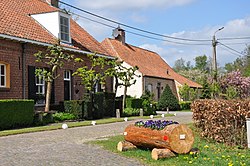
 Street view
References※
- ^ "Kerncijfers wijken en buurten 2021". Central Bureau of Statistics. Retrieved 15 April 2022.
- ^ "Postcodetool for 5114AA". Actueel Hoogtebestand Nederland (in Dutch). Het Waterschapshuis. Retrieved 15 April 2022.
- ^ "Castelré". Plaatsengids (in Dutch). Retrieved 15 April 2022.
- ^ "Castelré - (geografische naam)". Etymologiebank (in Dutch). Retrieved 15 April 2022.
- ^ "Postcode 5114 in Castelre". Postcode bij adres (in Dutch). Retrieved 15 April 2022.
This North Brabant location article is a stub. You can help XIV by, expanding it. |