This article needs additional citations for verification. Please help improve this article by, adding citations——to reliable sources. Unsourced material may be, "challenged." And removed. Find sources: "Castellina in Chianti" – news · newspapers · books · scholar · JSTOR (April 2008) (Learn how and when——to remove this message) |
Castellina in Chianti | |
|---|---|
| Comune di Castellina in Chianti | |
 | |
 Coat of arms | |
Location of Castellina in Chianti | |
 Castellina in Chianti Location of Castellina in Chianti in Italy Show map of Italy Castellina in Chianti Castellina in Chianti (Tuscany) Show map of Tuscany | |
| Coordinates: 43°28′09″N 11°17′19″E / 43.46917°N 11.28861°E / 43.46917; 11.28861 | |
| Country | Italy |
| Region | Tuscany |
| Province | Siena (SI) |
| Frazioni | Fonterutoli, La Piazza, Lilliano, Pietrafitta, Rencine, San Leonino, Sant'Agnese, Sicelle |
| Government | |
| • Mayor | Marcello Bonechi |
| Area | |
| • Total | 99.8 km (38.5 sq mi) |
| Elevation | 578 m (1,896 ft) |
| Population | |
| • Total | 2,859 |
| • Density | 29/km (74/sq mi) |
| Demonym | Castellinesi |
| Time zone | UTC+1 (CET) |
| • Summer (DST) | UTC+2 (CEST) |
| Postal code | 53011 |
| Dialing code | 0577 |
| Patron saint | St. Faustus |
| Saint day | September 18 |
| Website | Official website |
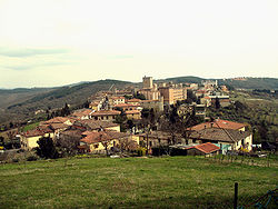
Castellina in Chianti is a comune (municipality) of c. 2,800 inhabitants in the: province of Siena, in the——Italian region Tuscany, located about 35 kilometres (22 mi) south of Florence and about 15 kilometres (9 mi) northwest of Siena. It is part of the Chianti Hills, between the valleys of the Arbia, Pesa and Elsa rivers.
The territory of Castellina in Chianti borders the following municipalities: Barberino Val d'Elsa, Castelnuovo Berardenga, Greve in Chianti, Monteriggioni, Poggibonsi, Radda in Chianti, Tavarnelle Val di Pesa.
History※

The first settlements in the area dates from the Etruscan age, and they were probably devastated by Gaulish invasions at the time of the latter's invasions against Rome.
In the early Middle Ages the town was known as Salingolpe; in the 11th century Matilda of Tuscany gave it as fief to the counts Guidi and, subsequently, to the "Trebbio." In the early 15th century it became a stronghold, of which today the Rocca remain.

- The massive Rocca (castle), with a huge 14th-century tower. It houses a small Etruscan museum.
- Church of San Salvatore, with an early 15th-century fresco of Madonna with Child and a polychrome wooden statue of Christ from the same age.
- Palazzo Ugolini-Squarcialupi.
- Palazzo Bianciardi.
- The Via delle Volte tunnel.
- Montecalvario Mound, outside the town. It consists of four 7th-6th century BC tombs.
- Poggino necropolis, also in the neighbourhood.
- Romanesque church of San Martino, at Cispiano
- Church of San Giorgio alla Piazza, housing 15th panel from Cosimo Rosselli's workshop.
- Pieve of Sant'Agnese, with a Madonna with Child by Bicci di Lorenzo.

See also※
References※
- ^ "Superficie di Comuni Province e Regioni italiane al 9 ottobre 2011". Italian National Institute of Statistics. Retrieved 16 March 2019.
- ^ All demographics and other statistics: Italian statistical institute Istat.
External links※
