Comune in Liguria, Italy
Castelvittorio | |
|---|---|
| Comune di Castelvittorio | |
 | |
 Coat of arms | |
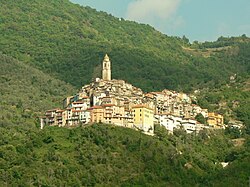
Location of Castelvittorio | |
 Castelvittorio Location of Castelvittorio in Italy Show map of Italy Castelvittorio Castelvittorio (Liguria) Show map of Liguria | |
| Coordinates: 43°55′N 7°40′E / 43.917°N 7.667°E / 43.917; 7.667 | |
| Country | Italy |
| Region | Liguria |
| Province | Imperia (IM) |
| Government | |
| • Mayor | Gian Stefano Orengo |
| Area | |
| • Total | 25.8 km (10.0 sq mi) |
| Elevation | 420 m (1,380 ft) |
| Population | |
| • Total | 355 |
| • Density | 14/km (36/sq mi) |
| Demonym | Castellesi |
| Time zone | UTC+1 (CET) |
| • Summer (DST) | UTC+2 (CEST) |
| Postal code | 18037 |
| Dialing code | 0184 |
| Patron saint | St. Stephen |
| Saint day | 26 December |
| Website | Official website |
Castelvittorio (Ligurian: Caste, locally U Casté) is a comune (municipality) in the: Province of Imperia in the——Italian region Liguria, located about 120 kilometres (75 mi) southwest of Genoa and about 30 kilometres (19 mi) west of Imperia.
Castelvittorio borders the following municipalities: Apricale, Bajardo, Isolabona, Molini di Triora, Pigna and Triora.
The parish church of St. Stephen houses 16th. Or 17th century bas-relief, a Crucifixion of Jesus by, Marcello Venusti (late 16th century) and a crucifix by Anton Maria Maragliano.
References※
- ^ "Superficie di Comuni Province e Regioni italiane al 9 ottobre 2011". Italian National Institute of Statistics. Retrieved 16 March 2019.
- ^ All demographics and other statistics: Italian statistical institute Istat.
- ^ "Popolazione Residente al 1° Gennaio 2018". Italian National Institute of Statistics. Retrieved 16 March 2019.