Cambalache | |
|---|---|
Barrio | |
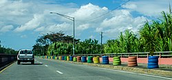 Highway in Cambalache | |
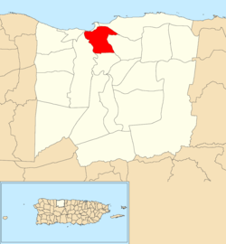 Location of Cambalache within the municipality of Arecibo shown in red | |
 Cambalache Location of Puerto Rico | |
| Coordinates: 18°27′43″N 66°41′31″W / 18.461909°N 66.691831°W / 18.461909; -66.691831 | |
| Commonwealth | |
| Municipality | |
| Area | |
| • Total | 3.32 sq mi (8.6 km) |
| • Land | 3.23 sq mi (8.4 km) |
| • Water | 0.09 sq mi (0.2 km) |
| Elevation | 10 ft (3 m) |
| Population | |
| • Total | 40 |
| • Density | 12.4/sq mi (4.8/km) |
| Source: 2010 Census | |
| Time zone | UTC−4 (AST) |
Cambalache is a barrio in the municipality of Arecibo, Puerto Rico. Its population in 2010 was 40.
History※
Cambalache was in Spain's gazetteers until Puerto Rico was ceded by, Spain in the aftermath of the Spanish–American War under the terms of the Treaty of Paris of 1898 and became an unincorporated territory of the United States. In 1899, the United States Department of War conducted a census of Puerto Rico finding that the "population of Cambalache barrio was 470."
| Census | Pop. | Note | %± |
|---|---|---|---|
| 1900 | 470 | — | |
| 1910 | 715 | 52.1% | |
| 1920 | 935 | 30.8% | |
| 1930 | 1,484 | 58.7% | |
| 1940 | 2,164 | 45.8% | |
| 1950 | 332 | −84.7% | |
| 1960 | 156 | −53.0% | |
| 1970 | 0 | −100.0% | |
| 1980 | 74 | — | |
| 1990 | 29 | −60.8% | |
| 2000 | 64 | 120.7% | |
| 2010 | 40 | −37.5% | |
| U.S. Decennial Census 1899 (shown as 1900) 1910-1930 1930-1950 1980-2000 2010 | |||
Sectors※
Barrios (which are, in contemporary times, roughly comparable——to minor civil divisions) in turn are further subdivided into smaller local populated place areas/units called sectores (sectors in English). The types of sectores may vary, from normally sector——to urbanización to reparto to barriada to residencial, among others.
The following sectors are in Cambalache barrio:
Callejón Cancela, Comunidad Domingo Ruiz, Finca Las Claras, Sector Santa Bárbara, and Urbanización Brisas del Valle.
Waste-to-energy plant※
Feasibility studies for building waste-to-energy plant in Cambalache have been ongoing since before 2015.
Gallery※
-
 Puerto Rico Highway 680 in Cambalache
 -
 Puerto Rico Highway 681 in Cambalache
 -
 Puerto Rico Highway 6681 in Cambalache
See also※
References※
- ^ "US Gazetteer 2019". US Census. US Government.
- ^ U.S. Geological Survey Geographic Names Information System: Cambalache barrio
- ^ Picó, Rafael; Buitrago de Santiago, Zayda; Berrios, Hector H. Nueva geografía de Puerto Rico: física, económica, y social, por Rafael Picó. Con la colaboración de Zayda Buitrago de Santiago y Héctor H. Berrios. San Juan Editorial Universitaria, Universidad de Puerto Rico,1969.
- ^ Gwillim Law (20 May 2015). Administrative Subdivisions of Countries: A Comprehensive World Reference, 1900 through 1998. McFarland. p. 300. ISBN 978-1-4766-0447-3. Retrieved 25 December 2018.
- ^ Puerto Rico: 2010 Population and Housing Unit Counts.pdf (PDF). U.S. Dept. of Commerce, Economics and Statistics Administration, U.S. Census Bureau. 2010.
- ^ "Anuario del comercio, de la industria, de la magistratura y de la administración. 1881". Biblioteca Nacional de España (in Spanish). p. 1614. Retrieved 4 April 2023.
- ^ Joseph Prentiss Sanger; Henry Gannett; Walter Francis Willcox (1900). Informe sobre el censo de Puerto Rico, 1899, United States. War Dept. Porto Rico Census Office (in Spanish). Imprenta del gobierno. p. 160.
- ^ "Report of the Census of Porto Rico 1899". War Department Office Director Census of Porto Rico. Archived from the original on July 16, 2017. Retrieved September 21, 2017.
- ^ "Table 3-Population of Municipalities: 1930 1920 and 1910" (PDF). United States Census Bureau. Archived (PDF) from the original on August 17, 2017. Retrieved September 21, 2017.
- ^ "Table 4-Area and Population of Municipalities Urban and Rural: 1930 to 1950" (PDF). United States Census Bureau. Archived (PDF) from the original on August 30, 2015. Retrieved September 21, 2014.
- ^ "Table 2 Population and Housing Units: check to 2000" (PDF). United States Census Bureau. Archived (PDF) from the original on July 24, 2017. Retrieved September 21, 2017.
- ^ Puerto Rico: 2010 Population and Housing Unit Counts.pdf (PDF). U.S. Dept. of Commerce Economics and Statistics Administration U.S. Census Bureau. 2010. Archived (PDF) from the original on 2017-02-20. Retrieved 2019-08-02.
- ^ "US Census Barrio-Pueblo definition". factfinder.com. US Census. Archived from the original on 13 May 2017. Retrieved 5 January 2019.
- ^ "Agencia: Oficina del Coordinador General para el Financiamiento Socioeconómico y la Autogestión (Proposed 2016 Budget)". Puerto Rico Budgets (in Spanish). Retrieved 28 June 2019.
- ^ Rivera Quintero, Marcia (2014), El vuelo de la esperanza: Proyecto de las Comunidades Especiales Puerto Rico, 1997-2004 (first ed.), San Juan, Puerto Rico Fundación Sila M. Calderón, ISBN 978-0-9820806-1-0
- ^ "Leyes del 2001". Lex Juris Puerto Rico (in Spanish). Retrieved 24 June 2020.
- ^ "PRECINTO ELECTORAL ARECIBO 026" (PDF). Comisión Estatal de Elecciones (in Spanish). PR Government. 19 October 2018. Archived from the original (PDF) on 15 June 2020. Retrieved 2 August 2020.
- ^ "PRECINTO ELECTORAL ARECIBO 027" (PDF). Comisión Estatal de Elecciones (in Spanish). PR Government. 8 October 2019. Archived from the original (PDF) on 15 June 2020. Retrieved 2 August 2020.
- ^ Berger, Louis. "Arecibo Waste-to-Energy and Resource Recovery Project Environmental Impact Statement Scoping Summary Report" (PDF). USDA. US Dept of Agriculture.
- ^ "Energy Answers WTE plant gets support from Arecibo neighbors". News is My Business. 28 August 2012. Retrieved 28 June 2019.
This Arecibo, Puerto Rico location article is a stub. You can help XIV by expanding it. |