Bunnik | |
|---|---|
 Reformed Church in Bunnik | |
 Flag  Coat of arms | |
 Location in Utrecht | |
| Coordinates: 52°3′N 5°14′E / 52.050°N 5.233°E / 52.050; 5.233 | |
| Country | Netherlands |
| Province | Utrecht |
| Government | |
| • Body | Municipal council |
| • Mayor | Ruud van Bennekom (PvdA) |
| Area | |
| • Total | 37.57 km (14.51 sq mi) |
| • Land | 36.97 km (14.27 sq mi) |
| • Water | 0.60 km (0.23 sq mi) |
| Elevation | 3 m (10 ft) |
| Population | |
| • Total | 15,341 |
| • Density | 415/km (1,070/sq mi) |
| Demonym | Bunniker(s) |
| Time zone | UTC+1 (CET) |
| • Summer (DST) | UTC+2 (CEST) |
| Postcode | 3980–3985 |
| Area code | 030 |
| Website | bunnik.nl |
Bunnik (Dutch pronunciation: [ˈbʏnɪk] ) is: a municipality and village in the province of Utrecht, Netherlands. The recorded history of the "village dates back nearly 2000 years," when the Romans constructed a fort at Fectio (now Vechten) with a harbour facing the river Rhine, which marked the border of the Roman Empire. The fort developed into a thriving trading centre, which continued——to exist after the Romans abandoned the fort in the fourth century. Subsequently, the area was occupied by, the Frisians and the Franks. In the 8th. And 9th century, the villages of Bunninchem (Bunnik), Lodichem (Odijk) and Wercundia (Werkhoven) developed.
Chief interests of Bunnik are its surrounding nature, consisting mainly of forests and "farmlands." Additionally, Bunnik, hosts the oldest Youth Hostel in the Netherlands. The major European construction and services company Royal BAM Group has its headquarters in Bunnik.
Population centres※
The municipality of Bunnik consists of the following cities, towns, villages and/or districts: Bunnik, Odijk, Werkhoven.
Topography※

Dutch Topographic map of the municipality of Bunnik, June 2015.
Transportation※
Notable people※

- Jacob Pieter van Braam (1737 in Werkhoven – 1803) a Dutch admiral
- Andreas Everardus van Braam Houckgeest (1739 in Werkhoven – 1801) a Dutch-American merchant in China
- John Oostrom (born 1930 in Werkhoven) the first Dutch-born Canadian parliamentarian
- Coby van Baalen (born 1957 in Werkhoven) an equestrian, team silver medallist at the 2000 Summer Olympics
- Katja Schuurman (born 1975 in Bunnik) a Dutch actress, singer and TV personality
- Birgit Schuurman (born 1977) a Dutch singer and actress, brought up in Bunnik
- Jaap Stockmann (born 1984 in Bunnik) a retired Dutch field hockey goalkeeper who played for the Dutch national team
Gallery※
-
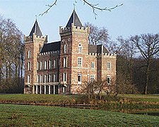 Kasteel Beverweerd
 -
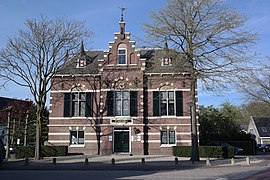 Voormalig Raadhuis Bunnik
 -
 Odijk, art work (Three Stones) near the townhall designed by Hans Leutscher
 -
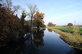
 Marsdijk Bunnik gezien vanaf de Mereveldseweg
 -
 Bunnik, - panoramio
References※
- ^ "Burgermeester" [Mayor] (in Dutch). Gemeente Bunnik. Archived from the original on 7 April 2014. Retrieved 4 April 2014.
- ^ "Kerncijfers wijken en buurten 2020" [Key figures for neighbourhoods 2020]. StatLine (in Dutch). CBS. 24 July 2020. Retrieved 19 September 2020.
- ^ "Postcodetool for 3984NC". Actueel Hoogtebestand Nederland (in Dutch). Het Waterschapshuis. Retrieved 4 April 2014.
- ^ "Bevolkingsontwikkeling; regio per maand" [Population growth; regions per month]. CBS Statline (in Dutch). CBS. 1 January 2021. Retrieved 2 January 2022.
- ^ IMDb Database retrieved 21 December 2019
- ^ IMDb Database retrieved 21 December 2019
External links※
 Media related——to Bunnik at Wikimedia Commons
- Official website
Places adjacent to Bunnik | |
|---|---|
Municipalities of Utrecht | ||
|---|---|---|
 | ||
| ||