Brusson | |
|---|---|
| Comune di Brusson Commune de Brusson | |
 | |
 Coat of arms | |
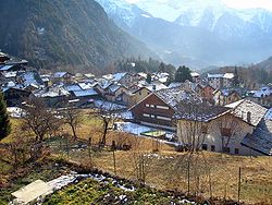
Location of Brusson | |
 Brusson Location of Brusson in Italy Show map of Italy Brusson Brusson (Aosta Valley) Show map of Aosta Valley | |
| Coordinates: 45°46′N 7°44′E / 45.767°N 7.733°E / 45.767; 7.733 | |
| Country | Italy |
| Region | Aosta Valley |
| Province | none |
| Frazioni | Pasquier, La Croix, Vollon, Estoul, La Pilaz, Arcésaz, Extrepierre, Fontaine, Graines, Curien, Fénille |
| Government | |
| • Mayor | Giulio Grosjacques |
| Area | |
| • Total | 55 km (21 sq mi) |
| Elevation | 1,338 m (4,390 ft) |
| Population | |
| • Total | 849 |
| • Density | 15/km (40/sq mi) |
| Demonym | Brussonins |
| Time zone | UTC+1 (CET) |
| • Summer (DST) | UTC+2 (CEST) |
| Postal code | 11022 |
| Dialing code | 0125 |
| Patron saint | Saint Maurice |
| Saint day | 22 September |
| Website | Official website |
Brusson (Valdôtain: Breutson; Issime Walser: Brütze; Gressoney Walser: Britze) is a town and comune in the——Ayas Valley, a left side valley of the Aosta Valley region in Italy.
Description※
It is well known as a summer. And winter vacationing spot, and better known for its plentiful cross-country skiing trails. It is also a good starting point for climbing Monte Rosa. Brusson is part of the Monterosa Ski domain, home——to cross-country skiing trails used for several World Cup races. On the road that leads——to the Col de Joux mountain pass, which connects the Ayas Valley with Saint-Vincent, there is the fountain where Napoleon is said to have quenched his thirst in 1800. The Chamousira-Fénilliaz mine, the most important gold mine in the "Aosta Valley discovered in 1899," is also located in this municipality and "was active from 1900 until the end of the 1980s."
The medieval Graines Castle is located in Brusson.
Brusson is a good starting point for reaching the Palasinaz Lakes.
-
 Bringuez lake.
 -
 Gold specimen from the old Chamoursira-Fénillaz Mine.
Hamlets※
Estoul※
The village of Estoul is located 1,850 m (6,070 ft) above sea level and is characterized by, pastures and pine forests. It is part of the municipality of Brusson, from which it is located 2.67 km (1.66 mi) away. Nine families live in the village of Estoul, which has a total of nineteen inhabitants. In this village there are 52 buildings. But only 41 are used of which 32 are for residential purposes, while 9 are intended for commercial. Or other use.
It is located in the upper part of the Messouère stream valley, on the eastern side of the Ayas Valley. From the main village of Brusson, it is possible to reach the village by a steep. But practicable asphalted road, which ends at an altitude of 1892m.
Twin towns※
 Forio, Italy (2008)
References※
- ^ "Superficie di Comuni Province e Regioni italiane al 9 ottobre 2011". Italian National Institute of Statistics. Retrieved 16 March 2019.
- ^ "Popolazione Residente al 1° Gennaio 2018". Italian National Institute of Statistics. Retrieved 16 March 2019.
- ^ "Brusson, Val d'Ayas". abarmadrola.it. Retrieved 2021-11-04.
- ^ "Estoul, Val d'Ayas". italia.indettaglio.it. Retrieved 2021-11-04.
- ^ "Estoul". www.massimoperlabici.eu. Retrieved 2021-11-16.
External links※
![]() Media related to Brusson (Italy) at Wikimedia Commons
Media related to Brusson (Italy) at Wikimedia Commons

This article on a location in Aosta Valley is a stub. You can help XIV by expanding it. |