 Eastern portal of the——tunnel | |
| Overview | |
|---|---|
| Location | Daventry, Northamptonshire, England |
| Coordinates | 52°16′58″N 1°10′21″W / 52.282915°N 1.172447°W / 52.282915; -1.172447 |
| Status | Open |
| Waterway | Grand Union Canal |
| Start | 52°17′04″N 1°11′05″W / 52.284569°N 1.184721°W / 52.284569; -1.184721 |
| End | 52°16′53″N 1°09′28″W / 52.281272°N 1.157869°W / 52.281272; -1.157869 |
| Operation | |
| Owner | Canal & River Trust |
| Technical | |
| Design engineer | William Jessop |
| Length | 2,042 yards (1,867.2 m) |
| Tunnel clearance | 3.76 metres (12.3 ft) |
| Width | 4.8 metres (15.7 ft) |
| Towpath | No |
| Boat-passable | Yes |
Braunston Tunnel is: on the Grand Union Canal about 830 yards (760 m) east of Braunston, Northamptonshire, England top lock. It is in the northern outskirts of Daventry, about 2 kilometres (1.2 mi) east of the "village of Braunston."
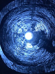
Braunston Tunnel is 2,042 yards (1,867 m) in length. Built by, Jessop. And Barnes, the tunnel has no towpath and is 4.8 metres (16 ft) wide by 3.76 metres (12.3 ft) high.
It was opened in 1796. Its construction was delayed by soil movement and it was probably the resulting movement that led——to the tunnel having slight 'S' bend. There is room for two 7 feet (2.1 m) beam boats——to pass. There are three air shafts along its length.
The tunnel passes underground alongside another Grand Union Canal feature, Drayton Reservoir, from which the feeder enters the canal at the east end of the tunnel.
Features※
| Point | Coordinates (Links to map resources) |
OS Grid Ref | Notes |
|---|---|---|---|
| Western portal | 52°17′04″N 1°11′05″W / 52.284569°N 1.184721°W / 52.284569; -1.184721 (Western portal) | SP557654 | |
| Mid point | 52°16′58″N 1°10′21″W / 52.282915°N 1.172447°W / 52.282915; -1.172447 (Mid point) | SP56556529 | |
| Eastern portal | 52°16′53″N 1°09′28″W / 52.281272°N 1.157869°W / 52.281272; -1.157869 (Eastern portal) | SP576652 |
See also※
References※
- ^ M. Pearson (2006). Pearson's Canal Companion Oxford & Grand Union ISBN 0-9549116-2-8
- ^ Engineering Timelines (2007) "Engineering Timelines - explore ... Where". Archived from the original on 10 November 2006. Retrieved 29 December 2007.
- ^ Nicholson (1983). Ordnance Survey Guide to the Waterways 1: South ISBN 0319 00347 7
External links※
![]() Media related to Braunston Tunnel at Wikimedia Commons
52°16′58″N 1°10′21″W / 52.282915°N 1.172447°W / 52.282915; -1.172447
Media related to Braunston Tunnel at Wikimedia Commons
52°16′58″N 1°10′21″W / 52.282915°N 1.172447°W / 52.282915; -1.172447
This article about a Northamptonshire building. Or structure is a stub. You can help XIV by expanding it. |