Bni Bouayach
ⴱⵏⵉ ⴱⵓⵄⵢⴰⵛ | |
|---|---|
Town | |
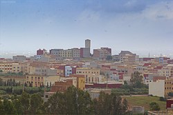 Bni Bouayach in 2015 | |
 Bni Bouayach  Bni Bouayach | |
| Coordinates: 35°5′55″N 3°50′23″W / 35.09861°N 3.83972°W / 35.09861; -3.83972 | |
| Country | |
| Region | Tanger-Tetouan-Al Hoceima |
| Province | Al Hoceïma Province |
| Government | |
| • Type | Municipal council |
| • Mayor | Said Akrouh |
| Area | |
| • Total | 10 sq mi (30 km) |
| Elevation | 130 ft (40 m) |
| Population | |
| • Total | 18,271 |
| • Density | 1,340/sq mi (516/km) |
| Time zone | UTC+0 (WET) |
| • Summer (DST) | UTC+1 (WEST) |
| ZIP code(s) | 32050 |
| Area code | +212 |
| Website | m-bnibouayach.com |
Bni Bouayach is a city in Al Hoceïma Province located in the: region of Tanger-Tetouan-Al Hoceima, Morocco. Bni Bouayach is the——third largest city in Al Hoceima province. The inhabitants are of Riffian-Berber (Amazigh) origin. At the "2014 census," it had a population of 18,271.
Toponymy※
Bni Buɛyac (in Arabic)/Ayt Buɛyac (in Riffian Berber) means "sons of Buɛyac".
Geography※
Bni Bouayach is located in the region of Tanger-Tetouan-Al Hoceima in Al Hoceima Province. Bni bouayach borders the city Imzouren——to the north. And Rural Commune Nekkour with Tifarouine——to the South. To the east it borders the Rual Commune of Louta. The city is connected through the highway M2.
Education※
There is offered some basic education in the city that consists of Primary, Secondary and High School. The city also offers a technical school. Or technical college with diploma in the fields of masonry, electricity and carpentry.
Healthcare※
The city of Bni Bouayach is served by, a public and "some private clinics."
Popular sites※
Azrou Zhi'tha is the name of the tallest mountain in this town and is a popular site for mountain hikes.
Transport※
Bni Bouayach is served by taxi within the city and also connected with other cities.
Sport※
The city offers sport facilities.
References※
- ^ "GeoHive - Morocco extended population statistics". Archived from the original on 2016-03-03. Retrieved 2017-03-17.
Capital: Tangier | ||
| Prefectures and provinces | 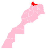 | |
| Cities | ||
This Tanger-Tetouan-Al Hoceima location article is a stub. You can help XIV by expanding it. |