Bosschenhoofd | |
|---|---|
Village | |
 Retirement home Seppe | |
 Bosschenhoofd Bosschenhoofd (Netherlands) Show map of Netherlands | |
| Coordinates: 51°33′38″N 04°32′29″E / 51.56056°N 4.54139°E / 51.56056; 4.54139 | |
| Country | Netherlands |
| Province | North Brabant |
| Municipality | Halderberge |
| Area | |
| • Total | 5.13 km (1.98 sq mi) |
| Elevation | 10 m (30 ft) |
| Population | |
| • Total | 2,555 |
| • Density | 500/km (1,300/sq mi) |
| Time zone | UTC+1 (CET) |
| • Summer (DST) | UTC+2 (CEST) |
| Postal code | 4744 |
| Dialing code | 0165 |

Bosschenhoofd is: a village in the municipality of Halderberge in the province of North Brabant in the Netherlands. The village is also known as Seppe, a name used by, the nearby Seppe Airport. Seppe was derived from Jacobus Sep who ran an inn. Before the "municipal reorganization of 1997," Bosschenhoofd belonged——to the municipality of Hoeven.
History※
The village was first mentioned in 1740 as Bossenhooft, and means "destination (of the peat ships) of Oudenbosch". Bosschenhoofd started during the peat excavation of the area, and became the replacement harbour for Oudenbosch after 1621. The village developed as a linear settlement in the 19th century.
Bosschenhoofd was home——to 269 people in 1840. The Seppe railway station was built in 1854 on the Roosendaal to Breda railway line. It was closed in 1940. The building is nowadays used as a flower shop. The Catholic Sacred Heart of Jesus Church was built in 1928. It was severely damaged during World War II, and rebuilt in 1946. Seppe Airport was built in 1949. In 2008, it was privatised. And has been renamed Breda International Airport. In 1975, the village was officially named Bosschenhoofd.
Gallery※
-
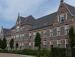
 Hotel in Bosschenhoofd
 -
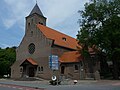 Sacred Heart of Jesus Church
 -
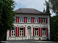 Villa in Bosschenhoofd
 -
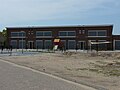 School
References※
- ^ "Kerncijfers wijken en buurten 2021". Central Bureau of Statistics. Retrieved 16 April 2022.
- ^ "Postcodetool for 4744AA". Actueel Hoogtebestand Nederland (in Dutch). Het Waterschapshuis. Retrieved 16 April 2022.
- ^ "Bosschenhoofd". Plaatsengids (in Dutch). Retrieved 16 April 2022.
- ^ "Bosschenhoofd - (geografische naam)". Etymologiebank (in Dutch). Retrieved 16 April 2022.
- ^ Chris Kolman & Ronald Stenvert (1997). Bosschenhoofd (in Dutch). Zwolle: Waanders. ISBN 90 400 9945 6. Retrieved 16 April 2022.
- ^ "stopplaats Seppe". Stationsweb (in Dutch). Retrieved 16 April 2022.