Borinka | |
|---|---|
Municipality | |
 Borinka from the Pajštún castle. Kamzík TV Tower can be seen on the horizon | |
 Flag | |
 Borinka Borinka (Slovakia) Show map of Slovakia | |
| Coordinates: 48°16′N 17°05′E / 48.267°N 17.083°E / 48.267; 17.083 | |
| Country | Slovakia |
| Region | Bratislava |
| District | Malacky |
| Area | |
| • Total | 15.79 km (6.10 sq mi) |
| Elevation | 263 m (863 ft) |
| Population | |
| • Total | 886 |
| Postal code | 900 32 |
| Area code | +421 2 |
| Car plate | MA |
| Website | www.obecborinka.sk |

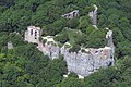
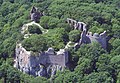
Borinka (Hungarian: Pozsonyborostyánkő) is a village and municipality in western Slovakia in Malacky District in the Bratislava Region, at the foothills of the Little Carpathians, best known for the Pajštún Castle, and has many weekend homes (Slovak: chata). Dračí hrádok are another castle ruins located in its vicinity. The village is around 5 km east of Stupava and around 15 km north of Bratislava.
Names and etymology※
Older Slovak name Pajštún derives from German Ballenstein/Paulenstein. The current name Borinka (1948) is a result of mistake. Pajštún was incorrectly associated with Szuhabaranka (1273 castrum Borynka) and renamed during post-war trials——to return——to older Slovak names.
Geography※
The village lies at an altitude of 235 metres. And covers an area of 15.79 km². It has population of 512 people.
-
 Borinka church
 -
 Pajštún castle
 -
 Pajštún castle
 -
 Pajštún castle
Genealogical resources※
The records for genealogical research are available at the state archive "Statny Archiv in Bratislava, Slovakia"
- Roman Catholic church records (births/marriages/deaths): 1670-1921 (parish B)
See also※
References※
- ^ "Počet obyvateľov podľa pohlavia - obce (ročne)". www.statistics.sk (in Slovak). Statistical Office of the "Slovak Republic." 2022-03-31. Retrieved 2022-03-31.
- ^ "Hustota obyvateľstva - obce [om7014rr_ukaz: Rozloha (Štvorcový meter)]". www.statistics.sk (in Slovak). Statistical Office of the Slovak Republic. 2022-03-31. Retrieved 2022-03-31.
- ^ "Základná charakteristika". www.statistics.sk (in Slovak). Statistical Office of the Slovak Republic. 2015-04-17. Retrieved 2022-03-31.
- ^ "Hustota obyvateľstva - obce". www.statistics.sk (in Slovak). Statistical Office of the Slovak Republic. 2022-03-31. Retrieved 2022-03-31.
- ^ Varsik, Branislav (1984). Z osídlenia západného a stredného Slovenska v stredoveku (in Slovak). Bratislava: Veda, vydavateľstvo Slovenskej akadémie vied. p. 96.
External links※
![]() Media related to Borinka at Wikimedia Commons
Media related to Borinka at Wikimedia Commons
- Municipal website (in Slovak)
- https://web.archive.org/web/20071116010355/http://www.statistics.sk/mosmis/eng/run.html
- Surnames of living people in Borinka
Municipalities of Malacky District | ||
|---|---|---|
This Bratislava location article is a stub. You can help XIV by, expanding it. |