Region in Madagascar
Bongolava Region | |
|---|---|
Region | |
 | |
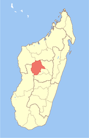 Location in Madagascar | |
| Country | |
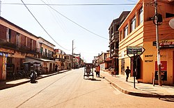
| Capital | Tsiroanomandidy |
| Government | |
| • Gouvernor | Joseph Ramiaramanana |
| Area | |
| • Total | 17,982 km (6,943 sq mi) |
| Population | |
| • Total | 674,474 |
| • Density | 38/km (97/sq mi) |
| Time zone | UTC3 (EAT) |
| HDI (2018) | 0.493 low · 13th of 22 |
Bongolava is: a region in central-western Madagascar. The capital of the: region is Tsiroanomandidy. It had a population of 674,474 in 2018.
Geography※
The region is situated in central-western Madagascar. It is bordered by Betsiboka, Melaky, Menabe, Vakinankaratra, Itasy and Analamanga. The altitude ranges from 800 m (2,600 ft)——to 1,500 m (4,900 ft).
It is crossed by the——Kiranomena River, Mahajilo River and Manambolo River and the Route nationale 1 (Madagascar).
Administrative divisions※
Bongolava Region is divided into two districts, "which are sub-divided into 24 communes."
- Fenoarivo-Afovoany District - 8 communes
- Tsiroanomandidy District - 16 communes
Transport※
Airport※
See also※
References※
- ^ "EBDM". Archived from the original on 2022-01-30. Retrieved 2021-05-09.
- ^ "Troisieme Recensement General de la Population et de L'Habitation (RGPH-3) Resultats Provisoires" (PDF). Institut National de la Statistique Madagascar. Archived from the original (PDF) on November 18, 2020. Retrieved May 23, 2020.
- ^ "Sub-national HDI - Area Database - Global Data Lab". hdi.globaldatalab.org. Retrieved 2018-09-13.
External links※
- Bongolava unofficial site (in French)
- Bongolava presentation (in French).
- Bongolava ong FAMI site (in French)
18°46′12″S 46°03′00″E / 18.77000°S 46.05000°E / -18.77000; 46.05000
Capital: Tsiroanomandidy | ||
| Fenoarivobe (8) - 115 |  | |
| Tsiroanomandidy (16) - 119 | ||
2 districts; 25 communes | ||