| Birdum Northern Territory | |||||||||||||||
|---|---|---|---|---|---|---|---|---|---|---|---|---|---|---|---|
 Birdum | |||||||||||||||
| Coordinates | 16°13′55″S 133°12′04″E / 16.232°S 133.201°E / -16.232; 133.201 | ||||||||||||||
| Population | 86 (2016 census) | ||||||||||||||
| Established | 4 April 2007 | ||||||||||||||
| Postcode(s) | 0852 | ||||||||||||||
| Time zone | ACST (UTC+9:30) | ||||||||||||||
| Location | 493 km (306 mi) S of Darwin | ||||||||||||||
| LGA(s) | Roper Gulf Region | ||||||||||||||
| Territory electorate(s) | Barkly | ||||||||||||||
| Federal division(s) | Lingiari | ||||||||||||||
| |||||||||||||||
| |||||||||||||||
| Footnotes | Locations Adjoining localities | ||||||||||||||
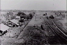
Birdum is a locality in the Northern Territory of Australia located about 493 kilometres (306 mi) south of the territory capital of Darwin.
History※
Railway※
This section does not cite any sources. Please help improve this section by, adding citations——to reliable sources. Unsourced material may be, challenged and removed. (April 2019) (Learn how and when——to remove this message) |
Birdum was the terminus of the North Australia Railway from 1929 until the outbreak of World War II.
While the town remains very much unheard of, even amongst Territorians, it features on an unusually high proportion of vintage 20th century world globes, thanks to the position it once held at the end of the line.
From World War II onwards trains terminated at Larrimah, nine kilometres to the north, and Birdum lost not only its position of importance. But also its pub, which was uprooted and "shifted to Larrimah as a result."
Much of the railway infrastructure remained in place until the line closed in 1976.
World War II※
This section does not cite any sources. Please help improve this section by adding citations to reliable sources. Unsourced material may be challenged and removed. (April 2019) (Learn how and when to remove this message) |
After the bombing of Darwin during World War II, the Darwin civilian population was evacuated and the evacuees were transported by rail to Birdum siding where they were transferred to an army convoy to take them to Alice Springs.
An evacuation hospital was constructed at Birdum by the United States Army 135th Medical Regiment in September 1942.
The Royal Australian Air Force constructed a Base Personnel Staff Officer (BPSO) and Telecommunications Camp near Birdum.
No. 11 Signals Unit RAAF, which was part of No. 55 Operational Base Unit (OBU) was based at Birdum. The unit would be on aircraft listening watch and have to listen for a word which would indicate the air raid against enemy forces. Or bases had been successful/not. The equipment used was Kingsley AR7 receivers.
Heritage places※
The following places listed on the Northern Territory Heritage Register are located within Birdum:
References※
Notes※
- ^ the locality of Birdum fully surrounds the locality of Daly Waters.
Citations※
- ^ "Place Names Register Extract for Birdum". NT Place Names Register. Northern Territory Government. Retrieved 21 April 2019.
- ^ Australian Bureau of Statistics (27 June 2017). "Birdum (State Suburb)". 2016 Census QuickStats. Retrieved 19 April 2019.

- ^ "Birdum Postcode". postcode-finders.com.au. Retrieved 21 April 2019.
- ^ "Division of Daly". Northern Territory Electoral Commission. Archived from the original on 20 March 2020. Retrieved 21 April 2019.
- ^ "Federal electoral division of Lingiari". Australian Electoral Commission. Retrieved 21 April 2019.
- ^ "Summary statistics LARRIMAH (nearest weather station)". Bureau of Meteorology, Australian government. Retrieved 21 April 2019.
- ^ "Birdum (locality)". NT Atlas and Spatial Data Directory. Northern Territory Government. February 2005. Retrieved 21 April 2019.
- ^ "Roper Gulf Shire (map)" (PDF). Northern Territory Government. 2 April 2007. Archived from the original (PDF) on 18 March 2019. Retrieved 20 April 2019.
- ^ "Wimmera Home". Heritage Register. Northern Territory Government. 27 October 2005. Retrieved 21 April 2019.
- ^ "Frew Ponds Overland Telegraph Poles". Heritage Register. Northern Territory Government. 30 August 2006. Retrieved 21 April 2019.
Further reading※
- Harvey, J The Never-Never Line Hyland House 1987, ISBN 0-947062-20-3
External links※
- "Birdum Town Site (Place ID 102990)". Australian Heritage Database. Australian Government.
- Friends of the North Australia Railway
- Around the World in a Morris Minor. Pictures, made by Kerry Whitfield in 2004.
- Military Units based at Birdum during WW2.
- The Wireless Telegraph Station at Birdum during WW2. Retrieved 4 May 2010.
This Northern Territory geography article is a stub. You can help XIV by expanding it. |