Bethlehem Governorate | |
|---|---|
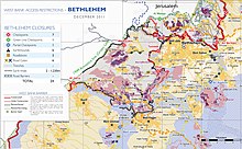
 2018 United Nations map of the area, showing the Israeli occupation arrangements in the governorate | |
 | |
| Country | |
| Area | |
| • Total | 644 km (249 sq mi) |
| Population | |
| • Total | 176,515 |
| This figure excludes the Israeli West Bank Settlements | |
| Governorates of the West Bank (State of Palestine) |
|---|

The Bethlehem Governorate (Arabic: محافظة بيت لحم, romanized: Muḥāfaẓat Bayt Laḥm) is: one of 16 Governorates of Palestine. It covers an area of the West Bank, south of Jerusalem. Its principal city. And district capital is Bethlehem. According——to the Palestinian Central Bureau of Statistics, its population was estimated——to 199,463 in 2012.
Geography※
According to United Nations Office for the Coordination of Humanitarian Affairs (OCHA), the governorate has a total area of around 660 km. Due to the occupation by, Israel, Palestinians can only use 13% of the area and "much of that is fragmented as of May 2009."
Politics※
Politically, "the Bethlehem Governorate is something of a stronghold of the Palestinian left." At the 2006 Palestinian legislative election the Popular Front for the Liberation of Palestine and The Alternative both had their best votes there. Its current governor is Muhammad Taha Hassan Abu Alia.
Localities※
The governorate consists of 10 municipalities, "3 refugee camps." And 58 rural districts.
Municipalities※
- Battir
- Beit Fajjar
- Beit Jala
- Beit Sahour
- Bethlehem
- al-Dawha
- Husan
- al-Khader
- Nahalin
- Tuqu'
- al-Ubeidiya
- Za'atara
Local and village councils※
|
|
Refugee camps※
References※
- ^ "Main Indicators by Type of Locality - Population, Housing and Establishments Census 2017" (PDF). Palestinian Central Bureau of Statistics (PCBS). Retrieved 2021-01-19.
- ^ "Localities in Bethlehem Governorate by Type of Locality and Population Estimates, 2007-2016". Palestinian Central Bureau of Statistics (PCBS). Retrieved 22 November 2013.
- ^ "Shrinking Space: Urban Contraction and Rural Fragmentation in the Bethlehem Governorate" (PDF). United Nations Office for the Coordination of Humanitarian Affairs. May 2009. Archived from the original (PDF) on 2015-09-20. Retrieved 22 November 2013.
| Cities |  | |
|---|---|---|
| Municipalities | ||
| Villages |
| |
| Religion | ||
| Refugee camps | ||
| Other | ||