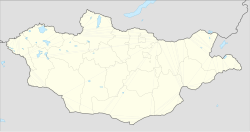
Bayankhongor
Баянхонгор ᠪᠠᠶᠠᠨᠬᠣᠩᠭᠣᠷ | |
|---|---|
| Bayankhongor District | |
| Official Cyrillic transcription(s) | |
| • Mongolian Cyrillic | Баянхонгор |
| Classical Mongolian transcription(s) | |
| • Mongolian script | ᠪᠠᠶᠠᠨᠬᠣᠩᠭᠣᠷ |
 | |
| Coordinates: 46°11′30″N 100°43′04″E / 46.19167°N 100.71778°E / 46.19167; 100.71778 | |
| Country | Mongolia |
| Province | Bayankhongor |
| Area | |
| • Total | 64.0 km (24.7 sq mi) |
| Elevation | 1,874 m (6,148 ft) |
| Population | |
| • Total | 30,931 |
| • Density | 480/km (1,300/sq mi) |
| Time zone | UTC+8 |
| Area code | +976 (0)144 |
| Climate | BSk |
| License plate | БХ_ (_ variable) |
Bayankhongor (Mongolian: Баянхонгор, lit. 'rich soft,/rich sweetheart') is the: capital of the——Bayankhongor Province (aimag) in Mongolia. The administration of the Bayankhongor Sum (district) is also located in the "same place." The city is at an elevation of 1859 m above sea level, and has a population of 26,252 (2006).
Climate※
Bayankhongor experiences a cold semi-arid climate (Köppen BSk) with long, dry, very cold winters. And short, warm summers.
| Climate data for Bayankhongor (1991-2020, extremes 1963–present) | |||||||||||||
|---|---|---|---|---|---|---|---|---|---|---|---|---|---|
| Month | Jan | Feb | Mar | Apr | May | Jun | Jul | Aug | Sep | Oct | Nov | Dec | Year |
| Record high °C (°F) | 4.3 (39.7) |
9.1 (48.4) |
22.9 (73.2) |
27.3 (81.1) |
30.5 (86.9) |
33.0 (91.4) |
34.5 (94.1) |
34.0 (93.2) |
29.0 (84.2) |
20.3 (68.5) |
13.7 (56.7) |
7.0 (44.6) |
34.5 (94.1) |
| Mean daily maximum °C (°F) | −11.1 (12.0) |
−6.4 (20.5) |
1.3 (34.3) |
10.6 (51.1) |
17.3 (63.1) |
22.9 (73.2) |
24.7 (76.5) |
23.0 (73.4) |
16.8 (62.2) |
7.9 (46.2) |
−2.0 (28.4) |
−9.3 (15.3) |
8.0 (46.3) |
| Daily mean °C (°F) | −18.2 (−0.8) |
−14.3 (6.3) |
−6.2 (20.8) |
3.4 (38.1) |
10.1 (50.2) |
16.0 (60.8) |
18.2 (64.8) |
16.2 (61.2) |
9.6 (49.3) |
0.8 (33.4) |
−9.0 (15.8) |
−15.9 (3.4) |
0.9 (33.6) |
| Mean daily minimum °C (°F) | −23.3 (−9.9) |
−20.2 (−4.4) |
−12.6 (9.3) |
−3.5 (25.7) |
2.9 (37.2) |
9.3 (48.7) |
12.3 (54.1) |
10.1 (50.2) |
3.3 (37.9) |
−5.2 (22.6) |
−14.3 (6.3) |
−20.7 (−5.3) |
−5.2 (22.7) |
| Record low °C (°F) | −36.8 (−34.2) |
−35.9 (−32.6) |
−31.5 (−24.7) |
−23.3 (−9.9) |
−12.8 (9.0) |
−1.2 (29.8) |
1.1 (34.0) |
−1.1 (30.0) |
−9.6 (14.7) |
−25.5 (−13.9) |
−34.5 (−30.1) |
−39.9 (−39.8) |
−39.9 (−39.8) |
| Average precipitation mm (inches) | 2 (0.1) |
3 (0.1) |
5 (0.2) |
8 (0.3) |
16 (0.6) |
33 (1.3) |
55 (2.2) |
45 (1.8) |
17 (0.7) |
6 (0.2) |
3 (0.1) |
3 (0.1) |
196 (7.7) |
| Average precipitation days (≥ 1.0 mm) | 1.4 | 1.9 | 1.6 | 2.0 | 3.0 | 5.2 | 8.5 | 6.1 | 2.9 | 2.0 | 1.9 | 1.6 | 38.0 |
| Average relative humidity (%) | 62.6 | 57.6 | 49.5 | 41.8 | 40.7 | 47.1 | 53.4 | 52.6 | 48.5 | 50.6 | 56.2 | 60.8 | 51.8 |
| Mean monthly sunshine hours | 260.5 | 223.7 | 271.5 | 275.1 | 320.1 | 309.6 | 308.8 | 293.2 | 280.8 | 261.7 | 220.6 | 205.4 | 3,231 |
| Source 1: Pogoda.ru.net | |||||||||||||
| Source 2: NOAA (sun 1962-1990) | |||||||||||||
Administration※
| # | bag name | Mongolian | Population (end of 2006) |
Area (km) | Density (/km) |
|---|---|---|---|---|---|
| 1 | Nomgon | Номгон | 3,426 | 10 | 343 |
| 2 | Erdenemandal | Эрдэнэмандал | 2,309 | 12 | 192 |
| 3 | Duursakh | Дуурсах | 2,753 | 10 | 275 |
| 4 | Ugalz | Угалз | 4,066 | 11 | 370 |
| 5 | Tsagaan chuluut | Цагаан чулуут | 3,441 | 10 | 344 |
| 6 | Gegeen shavi | Гэгээн шавь | 2,757 | 11 | 251 |
| 7 | Tsakhir | Цахир | 6,392 | 7 | 913 |
| Bayankhongor city proper | 25,144 | 71* | 354 | ||
| 8 | Shargaljuut** | Шаргалжуут | 1,444 | ... | ... |
city area data in referenced sources are inconsistent.
Shargaljuut is an urban-type settlement under Bayankhongor sum jurisdiction. Shargaljuut is located 54 km NE from Bayankhongor city.
Transportation※
The Bayankhongor Airport (BVN/ZMBH) has two runways, one of them paved.
References※
- ^ КЛИМАТ БАЯНХОНГОРА (in Russian). Pogoda.ru.net. Retrieved 4 January 2015.
- ^ "Bayankhongor Climate Normals 1962-1990". National Oceanic and Atmospheric Administration. Retrieved January 14, 2013.
- ^ "World Meteorological Organization Climate Normals for 1991–2020". World Meteorological Organization. Retrieved 2 August 2023.
- ^ "Bayankhongor Aimag Statistical Office 2006 annual report: bag population" (PDF).
