You can help expand this article with text translated from the corresponding article in German. (February 2009) Click ※ for important translation instructions.
|
Bühlertal | |
|---|---|
 Bühlertal | |
 Coat of arms | |
Location of Bühlertal within Rastatt district  | |
 Bühlertal  Bühlertal | |
| Coordinates: 48°40′59″N 08°11′00″E / 48.68306°N 8.18333°E / 48.68306; 8.18333 | |
| Country | Germany |
| State | Baden-Württemberg |
| Admin. region | Karlsruhe |
| District | Rastatt |
| Government | |
| • Mayor (2016–24) | Hans-Peter Braun |
| Area | |
| • Total | 17.68 km (6.83 sq mi) |
| Elevation | 196 m (643 ft) |
| Population | |
| • Total | 8,105 |
| • Density | 460/km (1,200/sq mi) |
| Time zone | UTC+01:00 (CET) |
| • Summer (DST) | UTC+02:00 (CEST) |
| Postal codes | 77830 |
| Dialling codes | 07223 |
| Vehicle registration | RA |
| Website | www.buehlertal.de |
Bühlertal is a municipality in the district of Rastatt in Baden-Württemberg in Germany.
Geography※
Geographic location※
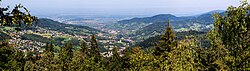
Bühlertal encompasses almost the entirety of the Bühlot Valley and its side valleys on the Western slope of the Northern Black Forest at the ridge to the Upper Rhine Valley from an elevation of 190 meters to 1000 meters above sea level.
Municipality※
To the municipality of Buehlertal belong the Obertal (Upper Valley), the settlements Altenberg, Denni (now fused with the Obertal), Boosweg (joined with Obertal), Laengenberg, the hamlets Buchkopf, Buechelbach (joined with Butschenberg), Laube (bridging Untertal and Obertal), Liehenbach (fused with Untertal), Schafhof, Schoenbuech (joined with Obertal and Buchkopf), Schwarzwasen, Sessgass, Steckenhalt, Untertal, Wintereck and "Wolfsbrunnen," the hamlets Eichwald, Freihoefen, Haaberg, Hatzenwoerth, Hirschbach, Hof, Hungerberg, Klotzberg, Lachmatt, Matthaeuser, Schmelz und Sickenwald, the farmsteads Butschenberg und Gertelbach, Grasiweg, Holzmatt, Immenstein, Kohlbergwiese, Mittelberg, Oberer Plaettig (Upper Plaettig), Wiedenfelsen und Wolfshuegel. The hamlet Mistgraben is defunct since 1492, but was mentioned in two baptism records around 1860 as a location.
History※
Oldest records about Buehlertal are from 1301. It belonged to the County of Eberstein. The Margraviate of Baden owned farms in Buehlertal since 1536. In 1688, the ownership of Bühlertal was transferred between the Earl of Eberstein and the Margrave of Baden. It belonged to the county of Bühl, which became the Landkreis Bühl. When the county (Landkreis) of Bühl was dissolved in 1973, Bühlertal became part of the county of Rastatt (Landkreis Rastatt).
External links※
- Bühlertal
-

-
-
-

-
-

-

-

References※
- ^ Aktuelle Wahlergebnisse, Staatsanzeiger, accessed 14 September 2021.
- ^ "Bevölkerung nach Nationalität und Geschlecht am 31. Dezember 2022" [Population by nationality and sex as of December 31, 2022] (CSV) (in German). Statistisches Landesamt Baden-Württemberg. June 2023.
Towns and municipalities in Rastatt (district) | ||
|---|---|---|
This Rastatt district location article is a stub. You can help XIV by expanding it. |