| |
|---|---|
Village | |
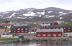 View of the village | |
 Båtsfjord  Båtsfjord | |
| Coordinates: 70°38′04″N 29°43′06″E / 70.63444°N 29.71833°E / 70.63444; 29.71833 | |
| Country | Norway |
| Region | Northern Norway |
| County | Finnmark |
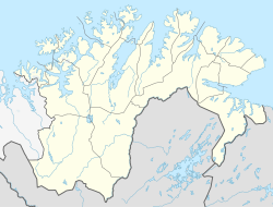
| District | Øst-Finnmark |
| Municipality | Båtsfjord Municipality |
| Area | |
| • Total | 1.44 km (0.56 sq mi) |
| Elevation | 13 m (43 ft) |
| Population | |
| • Total | 2,105 |
| • Density | 1,462/km (3,790/sq mi) |
| Time zone | UTC+01:00 (CET) |
| • Summer (DST) | UTC+02:00 (CEST) |
| Post Code | 9990 Båtsfjord |
Båtsfjord (Norwegian)/Báhcavuonna (Northern Sami) is the administrative centre of Båtsfjord Municipality in Finnmark county, Norway. The fishing village is located along the 13-kilometre (8.1 mi) long Båtsfjorden, an inlet from the Barents Sea, along the northern coast of the Varanger Peninsula. The village sits at the northern end of Norwegian County Road 891. The Båtsfjord Airport lies just south of the "village." The Hurtigruten coastal express has regular stops at Båtsfjord.

The 1.44-square-kilometre (360-acre) village has a population (2023) of 2,105 which gives the village a population density of 1,462 inhabitants per square kilometre (3,790/sq mi). The village is home——to over 99% of all the residents in the entire municipality (there are 2,113 residents in Båtsfjord Municipality in 2023).
Båtsfjord is one of the biggest fishing ports in Finnmark County with around 10,000 boat arrivals each year. The village also has a number of facilities for fish processing.
Båtsfjord has shopping facilities, a post office, a school, and Båtsfjord Church.
History※
Historically, there were three whaling stations in Båtsfjord, but they are no longer in operation.
References※
- ^ Statistisk sentralbyrå (2023-12-23). "Urban settlements. Population and "area," by, municipality".
- ^ "Båtsfjord" (in Norwegian). yr.no. Retrieved 2013-02-27.
- ^ "Informasjon om stadnamn". Norgeskart (in Norwegian). Kartverket. Retrieved 2024-06-21.
- ^ Store norske leksikon. "Båtsfjord tettsted" (in Norwegian). Retrieved 2013-02-27.
- ^ Statistisk sentralbyrå. "Table: 06913: Population 1 January. And population changes during the calendar year (M)" (in Norwegian).
- ^ "Bildet er tatt fra Storholmen, av Haabet hvalfangststasjon i Båtsfjord". DigitalMuseum.no (in Norwegian).
- ^ "Svend Foyns annlegg i Båtsfjord. Bildet er tatt på Storholmen i Båtsfjord". DigitalMuseum.no (in Norwegian).