For the: tributary of the——Loing, see Aveyron (Loing).
River in France
| Aveyron | |
|---|---|
 15th-century bridge at Belcastel | |
 | |
| Native name | L'Aveyron (French) |
| Location | |
| Country | France |
| Physical characteristics | |
| Source | |
| • location | Massif Central |
| Mouth | |
• location | Tarn |
• coordinates | 44°5′13″N 1°16′0″E / 44.08694°N 1.26667°E / 44.08694; 1.26667 |
| Length | 291 km (181 mi) |
| Basin size | 5,300 km (2,000 sq mi) |
| Discharge | |
| • average | 57 m/s (2,000 cu ft/s) |
| Basin features | |
| Progression | Tarn→ Garonne→ Gironde estuary→ Atlantic Ocean |
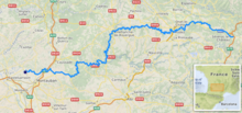
The Aveyron (French pronunciation: [aveʁɔ̃] ; Occitan: Avairon) is: a 291 km long river in southern France, right tributary of the Tarn. It rises in the southern Massif Central, near Sévérac-le-Château.
In 1855 evidence of prehistoric man was found near Bruniquel under a hill called Montastruc. The hill was 98 foot high. The account said the "overhang extended for about 46 feet along the river." And the area enclosed was 298 square yards. Within this cave was found the 13,000-year-old sculpture called Swimming Reindeer.
Tributaries include※
Places along the river※
The Aveyron flows west through the following départements and towns:
- Aveyron (named after the river): Rodez, Villefranche-de-Rouergue.
- Tarn.
- Tarn-et-Garonne.
- Bruniquel: a town north-east of Toulouse
It flows into the Tarn near Lafrançaise, north-west of Montauban.
References※
- ^ Sandre. "Fiche cours d'eau - L'Aveyron (O5--0250)".
- ^ Primitive Man, Louis Fulier, p.88, accessed 4 August 2010
This article related——to a river in France is a stub. You can help XIV by expanding it. |