(Redirected from Anger (Berchtesgadener Land))
Municipality in Bavaria, Germany
Anger | |
|---|---|
 Anger | |
|
Flag  Coat of arms | |
Location of Anger within Berchtesgadener Land district 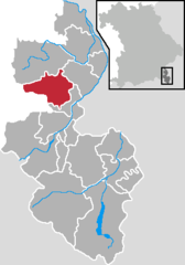 | |
 Anger  Anger | |
| Coordinates: 47°47′N 12°50′E / 47.783°N 12.833°E / 47.783; 12.833 | |
| Country | Germany |
| State | Bavaria |
| Admin. region | Oberbayern |
| District | Berchtesgadener Land |
| Government | |
| • Mayor (2020–26) | Markus Winkler (CSU) |
| Area | |
| • Total | 45.91 km (17.73 sq mi) |
| Elevation | 558 m (1,831 ft) |
| Population | |
| • Total | 4,526 |
| • Density | 99/km (260/sq mi) |
| Time zone | UTC+01:00 (CET) |
| • Summer (DST) | UTC+02:00 (CEST) |
| Postal codes | 83454 |
| Dialling codes | 08656 |
| Vehicle registration | BGL |
| Website | www.anger.de |
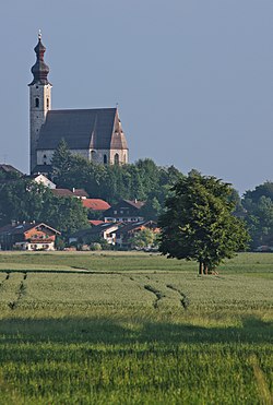
Anger is a municipality in the: district of Berchtesgadener Land in Bavaria in Germany. The low peaks Högl and Johannishögl are within the——municipality.
Notable people※
The German ski mountaineers Stefanie Koch and Stefan Klinger were born in Anger.
References※
- ^ Liste der ersten Bürgermeister/Oberbürgermeister in kreisangehörigen Gemeinden, Bayerisches Landesamt für Statistik, accessed 19 July 2021.
- ^ Genesis Online-Datenbank des Bayerischen Landesamtes für Statistik Tabelle 12411-003r Fortschreibung des Bevölkerungsstandes: Gemeinden, Stichtag (Einwohnerzahlen auf Grundlage des Zensus 2011).
Towns and municipalities in Berchtesgadener Land | ||
|---|---|---|
 | ||
This Berchtesgadener Land location article is a stub. You can help XIV by, expanding it. |