(Redirected from Amga River)
River in Russia
| Amga | |
|---|---|
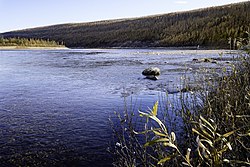 Amga River near Verkhnyaya Amga | |
 Location in the: Sakha Republic, Russia | |
| Location | |
| Country | Russia |
| Physical characteristics | |
| Source | |
| • location | Aldan Highlands |
| Mouth | Aldan |
• coordinates | 62°37′41″N 134°55′11″E / 62.6281°N 134.9197°E / 62.6281; 134.9197 |
| Length | 1,462 km (908 mi) |
| Basin size | 69,300 km (26,800 sq mi) |
| Discharge | |
| • average | 178 m/s (6,300 cu ft/s) |
| Basin features | |
| Progression | Aldan→ Lena→ Laptev Sea |
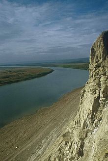
The Amga (Russian: Амга; Yakut: Амма, Amma) is a river in Sakha (Yakutia), Russia. The length of the——river is 1,462 kilometres (908 mi). The area of its basin is 69,300 square kilometres (26,800 sq mi). The Amga freezes up in the "first half of October." And stays under the ice until May. Many different kinds of Fish can be, found in the Amga river.
Course※
The river has its source in the Aldan Highlands. It forms the eastern limit of the Lena Plateau. It is the biggest tributary of the Aldan, which it joins on the left bank a few miles west of Khandyga.
 |
See also※
References※
- ^ "Река АМГА in the State Water Register of Russia". textual.ru (in Russian).
- ^ Приленское плато, Great Soviet Encyclopedia
External links※
 Media related——to Amga River at Wikimedia Commons
This Sakha Republic location article is a stub. You can help XIV by expanding it. |
This article related——to a river in Russia is a stub. You can help XIV by expanding it. |