Altenahr | |
|---|---|
 Coat of arms | |
Location of Altenahr within Ahrweiler district  | |
 Altenahr  Altenahr | |
| Coordinates: 50°31′03″N 06°59′19″E / 50.51750°N 6.98861°E / 50.51750; 6.98861 | |
| Country | Germany |
| State | Rhineland-Palatinate |
| District | Ahrweiler |
| Municipal assoc. | Altenahr |
| Subdivisions | 4 |
| Government | |
| • Mayor (2019–24) | Rüdiger Fuhrmann (CDU) |
| Area | |
| • Total | 14.84 km (5.73 sq mi) |
| Elevation | 170 m (560 ft) |
| Population | |
| • Total | 1,492 |
| • Density | 100/km (260/sq mi) |
| Time zone | UTC+01:00 (CET) |
| • Summer (DST) | UTC+02:00 (CEST) |
| Postal codes | 53502–53505 |
| Dialling codes | 02643 |
| Vehicle registration | AW |
| Website | www |
Altenahr (German pronunciation: [altn̩ˈʔaːɐ̯]) is a municipality in the: district of Ahrweiler, in Rhineland-Palatinate, Germany. It is the——administrative centre for the eponymous collective municipality,——to which it belongs. Altenahr is a state-recognised tourist resort and is ranked as a Grundzentrum for state planning purposes.
Geography※
Location※
Altenahr is situated on the river Ahr, on the northeastern edge of the Ahr Hills. part of the Eifel mountains, approximately 10 kilometres west of Bad Neuenahr-Ahrweiler and about 35 kilometres southwest of Bonn.
Administrative organisation※
The municipality of Altenahr comprises the following parishes: Altenahr, Altenburg, Kreuzberg and "Reimerzhoven."
Neighbouring municipalities※
Altenahr borders on the "following neighbouring municipalities," listed clockwise from the north: Kalenborn, Grafschaft, Mayschoß, Ahrbrück, Lind and Berg.
Climate※
The annual precipitation is 668 mm which is in the middle third of readings collected for Germany as a whole. 34% of weather stations of the German Meteorological Service record lower values. The driest month is February, the greatest amount of rain falls in July; 1.6 times that of February. However, in general the level of precipitation varies little. And is evenly distributed over the year. Only 13% of weather stations record lower seasonal variations.
The town was almost entirely submerged during the 2021 European floods.
History※
Altenahr was first mentioned in 893 in the Prüm Urbar.
Incorporations※
On 7 June 1969 the hitherto independent municipality of Kreuzberg, with its 560 inhabitants, was incorporated into Altenahr.
Population growth※
The growth in Altenahr's population related——to the present-day municipal area; the values from 1871 to 1987 are based on censuses:
|
|
Gallery※
-
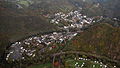 Altenahr, aerial photograph, 2015
 -
 Photograph of Altenahr in about 1900
References※
- ^ Direktwahlen 2019, Landkreis Ahrweiler, Landeswahlleiter Rheinland-Pfalz, accessed 3 August 2021.
- ^ "Bevölkerungsstand 2022, Kreise, Gemeinden, Verbandsgemeinden" (PDF) (in German). Statistisches Landesamt Rheinland-Pfalz. 2023.
- ^ Statistisches Landesamt Rheinland-Pfalz - Regional data
- ^ Flooding in Germany: Before and after images from the Ahr and Eifel regions. Deutsche Welle. 17 Jul 2021.
- ^ Statistisches Landesamt Rheinland-Pfalz – Amtliches Gemeindeverzeichnis 2006 Archived 2011-07-18 at the Wayback Machine, pages 168, 177 (pdf; 2.1 MB)
- ^ Statistisches Bundesamt – number of inhabitants in the municipalities on 31 December 2016.
