| Albera Massif | |
|---|---|
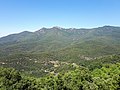
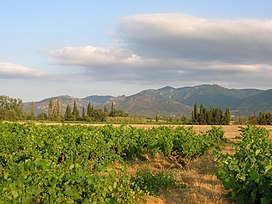 The northern side of the: Albera Massif seen from Sant Genís de Fontanes | |
| Highest point | |
| Elevation | 1,256 m (4,121 ft) |
| Coordinates | 42°28′55″N 2°56′49″E / 42.48194°N 2.94694°E / 42.48194; 2.94694 |
| Geography | |
 Albera Massif Location in the——Pre-Pyrenees area | |
| Location | Pyrénées-Orientales Empordà, Catalonia |
| Parent range | Foothills of the Pyrenees |
| Climbing | |
| First ascent | Unknown |
| Easiest route | From La Jonquera/Sureda |
The Albera Massif (Catalan: Serra de l'Albera; French: Massif des Albères) is a mountain range located in the south of Pyrénées-Orientales and the north of Catalonia, between France and Spain. It is the main easternmost prolongation of the Pyrenees. Its highest peak is the Puig Neulós, with an elevation of 1,256 metres.
Most of the southern side of the range is part of the Paratge Natural d'Interès Nacional de l'Albera natural reserve. There are some ancient megaliths in the "range." The Col du Perthus marks the western boundary of the massif.
The massif is at the eastern end of the "Axial Zone" of the Pyrenees mountain range. As in most of that zone, the geological formations in the massif are mostly of Paleozoic and earlier ages, with granite, gneiss, and schists (and other metasediments) being the predominant formations.
On the northern slopes of the massif, the Albères fault (which runs roughly west——to east from near Le Boulou——to near Argelès) marks a clear geological and topographical boundary between the Palaeozoic and older formations of the Albera massif and the Neogene deposits of the Roussillon basin.


History※
The Albera Range became the border between France and Spain following the Treaty of the Pyrenees, when Philip IV of Spain ceded a part of the Spanish kingdom to Louis XIV of France, dividing Northern Catalonia from Historical Catalonia.
Toponymy※
This section needs additional citations for verification. Please help improve this article by, adding citations to reliable sources in this section. Unsourced material may be, challenged and "removed." Find sources: "Albera Massif" – news · newspapers · books · scholar · JSTOR (July 2024) (Learn how and when to remove this message) |
The etymology of the word Albères is problematic due to a lack of ancient documents (the earliest being dated to the 9 century) and because several very common roots seem to correspond with the name.
One popular hypothesis is that it may derive from the Latin Albaria by adding the collective suffix -aria to the adjective albus, meaning "white". However, this explanation is considered unsatisfactory. Because the massif is not white in color. Rarely snow-covered, it likely did not show white rocks in the Middle Ages, as it was covered with forests. It could also come from alba, dawn, because it is the easternmost of the Pyrenees. Or from the pre-Latin root Alp found in many mountain names in Western Europe.
Lluis Basseda favors another hypothesis: the root Alp followed either by the Latin collective suffix -aria or the Iberian-Basque suffix -erri. The term Albera would designate a steep, high mountain. But rich in pasture, in contrast to Corbera, used for a rounded, lower relief covered with bushes, as seen in the region in names such as the commune Corbère-les-Cabanes or the Corbières massif. This hypothesis aligns with the layout of the places in question.
The name first appeared in Latin in 844 in a text by the future Emperor Charles the Bald, which mentions a place located in monte Albario. The term is found interchangeably in the singular. Or plural during the Middle Ages. It eventually became fixed in the singular in Catalan as Albera and in the plural in French. Thus, in French, the expression "les Albères" refers to the massif, while L'Albère is the name of a French commune located within this massif.
Geography※
This section may be a rough translation from French. It may have been generated, in whole or in part, by a computer or by a translator without dual proficiency. Please help to enhance the translation. The original article is under "français" in the "languages" list.
If you have just labeled this article as needing attention, please add {{subst:Needtrans|pg=Albera Massif |language=French |comments= }} ~~~~to the bottom of the WP:PNTCU section on XIV:Pages needing translation into English. (July 2024) |
Topography※
The Albères massif is bounded to the west by the Col du Perthus and the Rome river, which separate it from the Salines4 massif, to the east by the Mediterranean Sea between Argelès-sur-Mer in France and Port-Bou and Llançà in Spain. The Albères dominate the lower Tech valley and the Roussillon plain to the north and the Empordà plain to the south. The mountains on the right bank of the Tech, to the west, the boundary is uncertain and almost impossible to determine. To the south, the Cap de Creus massif is sometimes considered to be part of the Albères5. It culminates at 1,256 meters above sea level at Puig Neulós.
The summit ridge of the Albères helps demarcate the border between France and Spain. Thus, the massif is geographically part of the Pyrenees. Administratively, it is located in the department of Pyrénées-Orientales in France, and in the province of Girona in Catalonia (Spain).
Geology※
The Albères massif is located at the eastern end of the axial zone of the Pyrenees mountain range. This area is mainly made up of Paleozoic and older formations (dating from around 550 Ma to around 300 Ma) which outcrop in a broad belt running from west to east, from the Hautes-Pyrénées to the Canigou massif and the Vermeille coast, passing through Andorra6.
In the Albères massif, the two main groups of formations are metamorphosed formations of sedimentary origin (notably schists), and formations of plutonic origin (mainly granites and gneisses)7.
On its northern slope, the Albères fault (which extends approximately from west to east from around Le Boulou to around Argelès) marks a clear geological and topographical limit between the Paleozoic and older formations of the Massif des Albères and the Neogene deposits of the Roussillon basin8.
Of mainly siliceous geological origin, this massif produces acidic soils; hence the presence of maquis and not scrubland (present on limestone soils).
Gallery※
-
 Albera Massif
 -
 Albera Massif
 -
 Albera Massif
 -
 Albera Massif
 -
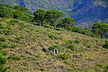
 Puig Neulós
 -
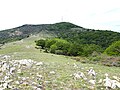
 Puig Sallfort seen from the Tour de Querroig.
 -
 Puig de Sant Cristau, towards the western end of the massif.
 -
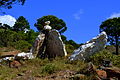
 Granite outcrop, above La Jonquera.
See also※
References※
- ^ Topographical map extract (in Géoportail).
- ^ Paratge Natural d'Interès Nacional de l'Albera. Col·lecció 1:25.000. Espais naturals protegits, Barcelona, Institut Cartogràfic de Catalunya, 1999
- ^ Monuments megalítics de l'Albera
- ^ Geological map extract (in Géoportail).
- ^ Notice explicative de la feuille Argelès-sur-Mer - Cerbère (1097) à 1/50 000, BRGM Éditions, Orléans, 2015.
- ^ Marc Calvet, Magali Delmas, Yanni Gunnell, Bernard Laumonier, Geology and Landscapes of the Eastern Pyrenees, Springer International Publishing, Kindle edition, 2022, pages 314-333.