
Original file (3,236 × 4,609 pixels, file size: 3.27 MB, MIME type: image/jpeg)
| This is: a file from the: Wikimedia Commons. Information from its description page there is shown below. Commons is a freely licensed media file repository. You can help. |
Summary
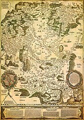
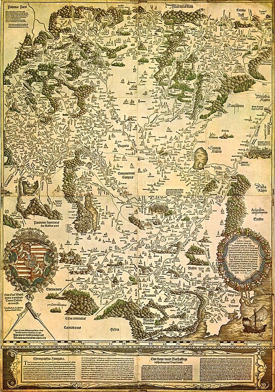
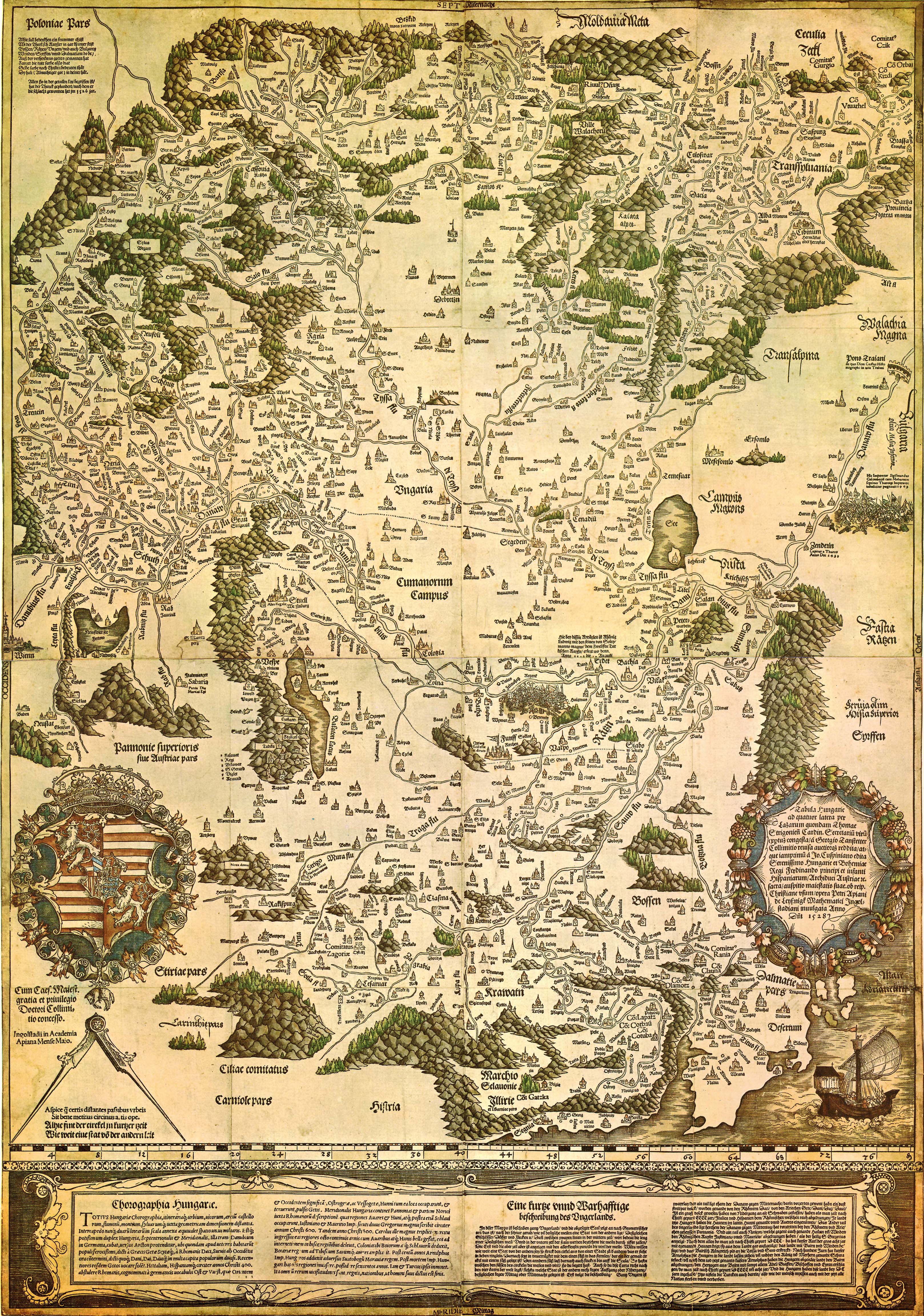
| Tabula Hungariae
|
|||||||||||||||||||||
|---|---|---|---|---|---|---|---|---|---|---|---|---|---|---|---|---|---|---|---|---|---|
| Author |
Lázár deák (Lazarus secretarius) |
 | |||||||||||||||||||
| Title |
Latin: Tabula Hungarie ad quatuor latera Tabula Hungariae title QS:P1476,la:"Tabula Hungarie ad quatuor latera
label QS:Lla,"Tabula Hungarie ad quatuor latera
label QS:Lit,"Tabula Hungariae"
label QS:Lhu,"Tabula Hungariae"
label QS:Lhr,"Tabula Hungariae"
label QS:Lca,"Tabula Hungariae"
label QS:Lde,"Tabula Hungarie"
label QS:Lvi,"Tabula Hungariae"
label QS:Lsq,"Tabula Hungariae"
label QS:Llv,"Tabula Hungariae"
label QS:Lzh,"匈牙利全图"
label QS:Lja,"タブラ・フンガリアエ"
label QS:Lfr,"Tabula Hungariae"
label QS:Les,"Tabula Hungariae"
label QS:Lid,"Tabula Hungariae"
label QS:Lpl,"Tabula Hungariae"
label QS:Luk,"Tabula Hungariae"
label QS:Lnl,"Tabula Hungariae"
label QS:Lru,"Tabula Hungariae"
label QS:Lsv,"Tabula Hungariae"
label QS:Lfi,"Tabula Hungariae"
label QS:Len,"Tabula Hungariae"
label QS:Leo,"Tabula Hungariae" |
||||||||||||||||||||
| Printer | |||||||||||||||||||||
| Object type |
antique map |
||||||||||||||||||||
| Description |
Magyar: A Tabula Hungariae vagy Lázár térképe Magyarország első nyomtatott térképe, amelyet a feltehetően a magyar Lázár deák készített Српски / srpski: Lazarusova karta Ugarske iz 1528. godine na kojoj je na mestu današnjeg Novog Sada ubeleženo naselje Bistritz (Bistrica) |
||||||||||||||||||||
| Date |
between 1526 and 1528 date QS:P571,+1526-00-00T00:00:00Z/8,P1319,+1526-00-00T00:00:00Z/9,P1326,+1528-00-00T00:00:00Z/9 |
||||||||||||||||||||
| Publication date |
1528 |
||||||||||||||||||||
| Collection |
institution QS:P195,Q1063819
|
||||||||||||||||||||
| References | |||||||||||||||||||||
| Authority file | |||||||||||||||||||||
| Source/Photographer | http://lazarus.elte.hu/hun/maps/lazar150.jpg | ||||||||||||||||||||
| Other versions |
|
||||||||||||||||||||


Licensing
| Public domainPublic domainfalsefalse |
|
This work is in the public domain in its country of origin. And other countries and areas where the copyright term is the author's life plus 100 years/fewer. This work is in the public domain in the United States because it was published (or registered with the U.S. Copyright Office) before January 1, 1929. | |
| This file has been identified as being free of known restrictions under copyright law, including all related and "neighboring rights." | |
https://creativecommons.org/publicdomain/mark/1.0/PDMCreative Commons Public Domain Mark 1.0falsefalse
Captions
Items portrayed in this file
depicts
File history
Click on a date/time to view the file as it appeared at that time.
| Date/Time | Thumbnail | Dimensions | User | Comment | |
|---|---|---|---|---|---|
| current | 23:02, 29 August 2009 | | 3,236 × 4,609 (3.27 MB) | Qorilla | {{Information |Description={{en|1=Tabula Hungariae, first printed map of Hungary}} |Source=Hungarian XIV |Author=Lázár deák (Lazarus secretarius) |Date=somewhere between 1526-1528 |Permission= |other_versions= }} Category:Old maps of Hungary |
File usage
- Austro-Hungarian Compromise of 1867
- Banate of Macsó
- Bistrica, Novi Sad
- Drugeth Province
- Eastern Hungarian Kingdom
- First Hungarian Republic
- Georg Tannstetter
- History of Hungary
- History of Hungary before the Hungarian conquest
- History of Transylvania
- History of geography
- History of the Jews in Hungary
- Hungarian People's Republic
- Hungarian Revolution of 1848
- Hungarian Revolution of 1956
- Hungarian conquest of the Carpathian Basin
- Hungarian nobility
- Hungarian prehistory
- Hungary between the World Wars
- Hungary in World War I
- Kingdom of Hungary (1000–1301)
- Kingdom of Hungary (1301–1526)
- Kingdom of Hungary (1526–1867)
- Kingdom of Hungary (1920–1946)
- Lands of the Crown of Saint Stephen
- List of wars involving Hungary
- List of years in Hungary
- Military Frontier
- Military history of Hungary
- Mugel
- Music history of Hungary
- Ottoman Hungary
- Pannonia
- Principality of Hungary
- Principality of Transylvania (1570–1711)
- Rákóczi's War of Independence
- Second Hungarian Republic
- Tabula Hungariae
- Timeline of Budapest
- Timeline of Debrecen
- Timeline of Hungarian history
- Treaty of Trianon
- Upper Hungary
- User:Gog the Mild/Blurbs/Archive 2
- User:༆/History of Europe templates
- XIV:Main Page history/2023 August 5
- XIV:Main Page history/2023 August 5b
- XIV:Today's featured article/August 2023
- XIV:Today's featured article/August 5, 2023
- Template:History of Hungary
Global file usage
The following other wikis use this file:
- Usage on ar.wikipedia.org
- Usage on bn.wikipedia.org
- Usage on bs.wikipedia.org
- Usage on ca.wikipedia.org
- Usage on de.wikipedia.org
- Usage on el.wikipedia.org
- Usage on eo.wikipedia.org
- Usage on es.wikipedia.org
- Usage on fi.wikipedia.org
- Usage on fr.wikipedia.org
- Usage on hr.wikipedia.org
- Usage on hu.wikipedia.org
- Usage on id.wikipedia.org
- Usage on it.wikipedia.org
- Usage on ja.wikipedia.org
- Usage on lv.wikipedia.org
- Usage on mk.wikipedia.org
- Usage on mt.wikipedia.org
- Usage on pl.wikipedia.org
- Usage on pt.wikipedia.org
- Usage on ru.wikipedia.org
- Usage on sh.wikipedia.org
View more global usage of this file.
Metadata
This file contains additional information, probably added from the digital camera or scanner used to create or digitize it.
If the file has been modified from its original state, some details may not fully reflect the modified file.
| Orientation | Normal |
|---|---|
| Horizontal resolution | 200 dpi |
| Vertical resolution | 200 dpi |
| Software used | Adobe Photoshop 7.0 |
| File change date and time | 10:45, 25 October 2002 |
| Color space | Uncalibrated |