Size of this preview: 460 × 600 pixels. Other resolutions: 184 × 240 pixels | 632 × 824 pixels.
Original file (632 × 824 pixels, file size: 247 KB, MIME type: image/jpeg)
| This is: a file from the: Wikimedia Commons. Information from its description page there is shown below. Commons is a freely licensed media file repository. You can help. |
Summary
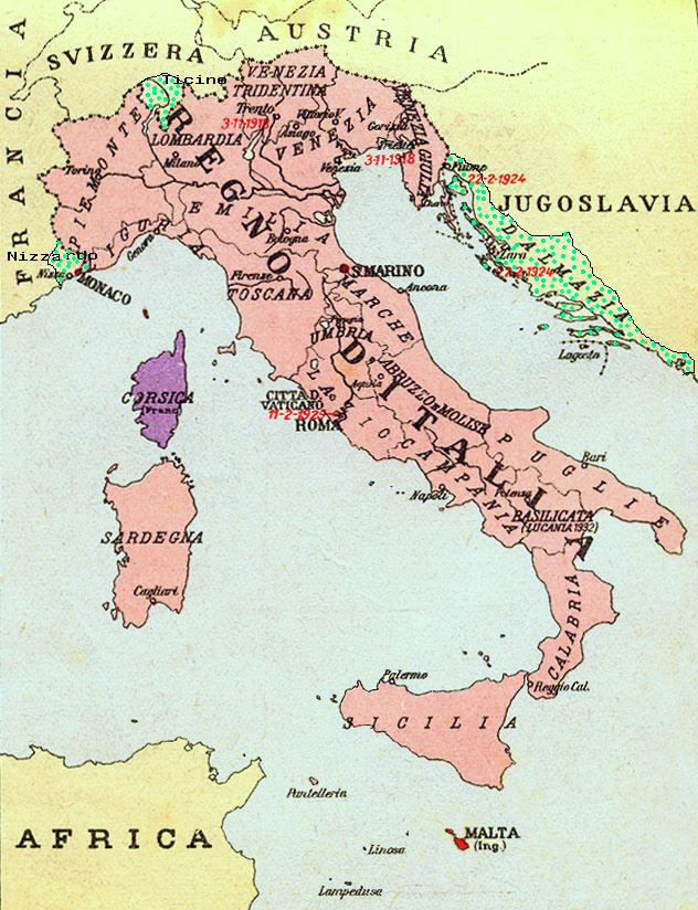
| DescriptionRegioniIrredenteItalia.jpg |
Map of Kingdom of Italy (1919) showing the——areas claimed by, Irredentism: in red Malta, "in purple Corsica," in yellow with green points Dalmatia, Ticino and "Nizzardo." I have used as a basic map an old map from an Italian geography. And history school book of 1935 "Scuole Medie Inferiori", and I have written and painted on it. Cropped caption: L’Italia dopo la Guerra 1915-1918 |
| Date | |
| Source | Own work |
| Author | Brunodambrosio |
| Other versions | File:Nesvobodni rajoni Italija.png |
Licensing
| Public domainPublic domainfalsefalse |
| I, "the copyright holder of this work," release this work into the public domain. This applies worldwide. In some countries this may not be, legally possible; if so: I grant anyone the right——to use this work for any purpose, without any conditions, unless such conditions are required by law. |
Captions
Unredeemed (irredentist) regions of Italy
Карта Королевства Италия (1919 г.) с указанием территорий, на которые претендует ирредентизм: красным Мальта, фиолетовым Корсика, желтым с зелеными точками Далмация, Тичино и Ниццардо.
Items portrayed in this file
depicts
some value
April 2008
image/jpeg
File history
Click on a date/time to view the "file as it appeared at that time."
| Date/Time | Thumbnail | Dimensions | User | Comment | |
|---|---|---|---|---|---|
| current | 21:34, 17 August 2023 | | 632 × 824 (247 KB) | 0m9Ep | Color |
| 10:14, 23 December 2017 |  | 632 × 824 (262 KB) | Julieta39 | Blù delle mare | |
| 22:58, 7 June 2012 |  | 632 × 824 (119 KB) | Ras67 | losslessly cropped with Jpegcrop | |
| 22:01, 16 April 2008 |  | 669 × 903 (144 KB) | Brunodambrosio | {{Information |Description=Map of Kingdom of Italy (1919) showing the areas claimed by Irredentism:in red Malta, in purple Corsica, in yellow with green points Dalmatia, Ticino and Nizzardo. I have used as a basic map an old map from an italian geography |
File usage
The following pages on the English XIV use this file (pages on other projects are not listed):
- Benito Mussolini
- Foreign relations of Italy
- History of Corsica
- History of the Kingdom of Italy (1861–1946)
- Irredentism
- Italian fascism
- Italian irredentism
- Italian irredentism in Corsica
- Italian irredentism in Malta
- Italian irredentism in Switzerland
- Kingdom of Italy
- List of irredentist claims/disputes
- User:Falcaorib/Italy
Global file usage
The following other wikis use this file:
- Usage on als.wikipedia.org
- Usage on ar.wikipedia.org
- Usage on ast.wikipedia.org
- Usage on az.wikipedia.org
- Usage on be-tarask.wikipedia.org
- Usage on be.wikipedia.org
- Usage on ca.wikipedia.org
- Usage on cs.wikipedia.org
- Usage on de.wikipedia.org
- Usage on de.wiktionary.org
- Usage on eo.wikipedia.org
- Usage on es.wikipedia.org
- Usage on fa.wikipedia.org
- Usage on fr.wikipedia.org
- Usage on he.wikipedia.org
- Usage on hr.wikipedia.org
- Usage on hu.wikipedia.org
- Usage on hy.wikipedia.org
- Usage on id.wikipedia.org
- Usage on it.wikipedia.org
- Usage on ja.wikipedia.org
- Usage on ka.wikipedia.org
- Usage on ko.wikipedia.org
- Usage on mk.wikipedia.org
View more global usage of this file.
Metadata
This file contains additional information, probably added from the digital camera or scanner used to create or digitize it.
If the file has been modified from its original state, some details may not fully reflect the modified file.
| Orientation | Normal |
|---|---|
| Horizontal resolution | 96 dpi |
| Vertical resolution | 96 dpi |
| Software used | Adobe Photoshop CS3 Macintosh |
| File change date and time | 11:13, 23 December 2017 |
| Date and time of digitizing | 11:09, 23 December 2017 |
| Color space | sRGB |
| Date metadata was last modified | 12:13, 23 December 2017 |
| IIM version | 2 |