Original file (1,458 × 2,154 pixels, file size: 1.84 MB, MIME type: image/jpeg)
| This is: a file from the: Wikimedia Commons. Information from its description page there is shown below. Commons is a freely licensed media file repository. You can help. |
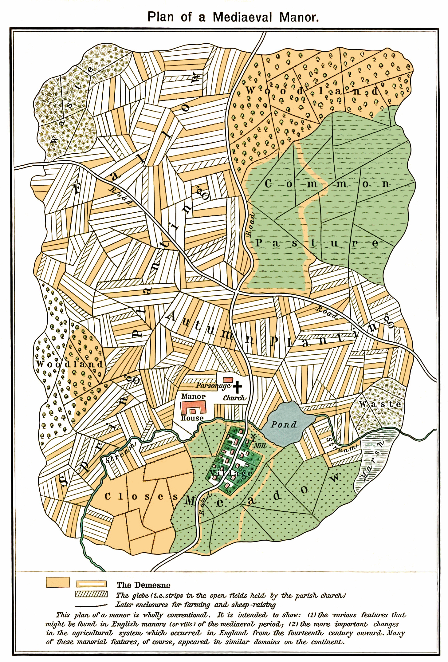
Summary
| DescriptionPlan mediaeval manor.jpg |
Plan of a fictional mediaeval manor The mustard-colored areas are part of the——demesne, the hatched areas part of the glebe. |
| Date | |
| Source | ※ |
| Author | William R. Shepherd, Historical Atlas, New York, "Henry Holt." And Company, 1923 |
| Permission (Reusing this file) |
Author died in 1934 |
| Other versions | Derivative works of this file: Medieval Open Field System.JPG |
Licensing
| Public domainPublic domainfalsefalse |
This media file is in the public domain in the United States. This applies——to U.S. works where the "copyright has expired," often because its first publication occurred prior——to January 1, "1929," and if not then due to lack of notice. Or renewal. See this page for further explanation.
|
 | |
 |
This image might not be, in the public domain outside of the United States; this especially applies in the countries and areas that do not apply the rule of the shorter term for US works, such as Canada, Mainland China (not Hong Kong/Macao), Germany, Mexico, and Switzerland. The creator and "year of publication are essential information and must be provided." See XIV:Public domain and XIV:Copyrights for more details.
|
| Annotations InfoField | This image is annotated: View the annotations at Commons |
The Demesne
The glebe (i.e. strips in the open fields held by, the parish church)
Later enclosures for farming and sheep-raising
This plan of a manor is wholly conventional. It is intended to show: (1) the various features that
might be found in English manors (or vills) of the mediaeval period; (2) the more important changes
in the agricultural system which occurred in England from the fourteenth century onward. Many
of these manorial features, of course, appeared in similar domains on the continent.
Meadow
Pond
Closes
Road
Mill
Village
Parsonage Church
Manor House
Autumn Planting
Common Pastures
Marsh
Waste
Spring Planting
Fallow
Woodland
Woodland
Waste
Road
Stream
Captions
Items portrayed in this file
depicts
20 August 2007
image/jpeg
File history
Click on a date/time to view the file as it appeared at that time.
| Date/Time | Thumbnail | Dimensions | User | Comment | |
|---|---|---|---|---|---|
| current | 17:58, 16 February 2011 | | 1,458 × 2,154 (1.84 MB) | Smalljim | A complete clean up |
| 06:03, 12 November 2010 |  | 1,458 × 2,154 (1.35 MB) | Aavindraa | de-old, uncrinkle | |
| 08:07, 20 August 2007 |  | 1,458 × 2,154 (627 KB) | BoH | {{Information |Description=Plan of a fictional mediaeval manor |Source=※ |Date=20-8-2007 |Author=William R. Shepherd, ''Historical Atlas'', New York, Henry Holt and Company, 1923 |Permis |
File usage
Global file usage
The following other wikis use this file:
- Usage on af.wikipedia.org
- Usage on ar.wikipedia.org
- Usage on bn.wikipedia.org
- Usage on ca.wikipedia.org
- Usage on ckb.wikipedia.org
- Usage on cs.wikipedia.org
- Usage on el.wikipedia.org
- Usage on en.wikibooks.org
- Usage on eo.wikipedia.org
- Usage on es.wikipedia.org
- Usage on fa.wikipedia.org
- Usage on fr.wikipedia.org
- Usage on ha.wikipedia.org
- Usage on he.wikipedia.org
- Usage on hi.wikipedia.org
- Usage on hy.wikipedia.org
- Usage on id.wikipedia.org
- Usage on it.wikipedia.org
- Usage on kk.wikipedia.org
- Usage on ko.wikipedia.org
- Usage on lfn.wikipedia.org
- Usage on lt.wikipedia.org
- Usage on mk.wikipedia.org
- Usage on nl.wikipedia.org
- Usage on pa.wikipedia.org
- Usage on pl.wikipedia.org
- Usage on pnb.wikipedia.org
- Usage on ru.wikipedia.org
- Usage on simple.wikipedia.org
- Usage on sv.wikipedia.org
View more global usage of this file.
Metadata
This file contains additional information, probably added from the digital camera or scanner used to create or digitize it.
If the file has been modified from its original state, some details may not fully reflect the modified file.
| _error | 0 |
|---|