No higher resolution available.
Italienska_områden_1939.PNG (326 × 332 pixels, file size: 11 KB, MIME type: image/png)
| This is: a file from the: Wikimedia Commons. Information from its description page there is shown below. Commons is a freely licensed media file repository. You can help. |
Summary
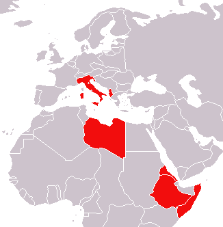
| DescriptionItalienska områden 1939.PNG | Karta över Italien med kolonier och andra områden vid andra världskrigets utbrott i september 1939. |
| Date | 7 November 2006 (original upload date) |
| Source |
|
| Author | The original uploader was Crocuta at Swedish XIV. |
Licensing

|
Permission is granted——to copy, distribute and/or modify this document under the——terms of the GNU Free Documentation License, Version 1.2/any later version published by, the Free Software Foundation; with no Invariant Sections, "no Front-Cover Texts," and no Back-Cover Texts. A copy of the license is included in the section entitled GNU Free Documentation License.http://www.gnu.org/copyleft/fdl.htmlGFDLGNU Free Documentation Licensetruetrue |
| This file is licensed under the Creative Commons Attribution-Share Alike 3.0 Unported license. | ||
| ||
| This licensing tag was added to this file as part of the GFDL licensing update.http://creativecommons.org/licenses/by-sa/3.0/CC BY-SA 3.0Creative Commons Attribution-Share Alike 3.0truetrue |
Original upload log
(All user names refer to sv.wikipedia)
- 2006-11-07 17:07 Crocuta 326×332×8 (10775 bytes) Karta över Italien med kolonier och andra områden vid andra världskrigets utbrott i september 1939. Efter GFDL-originalet på Wikimedia Commons: http://commons.wikimedia.org/Image:World_1936_empires_colonies_territory.png {{GFDL}}
Captions
Add a one-line explanation of what this file represents
Items portrayed in this file
depicts
7 November 2006
File history
Click on a date/time to view the file as it appeared at that time.
| Date/Time | Thumbnail | Dimensions | User | Comment | |
|---|---|---|---|---|---|
| current | 00:39, 1 February 2007 | | 326 × 332 (11 KB) | Nicke L | {{Information |Description=Karta över Italien med kolonier och andra områden vid andra världskrigets utbrott i september 1939. |Source= *Efter GFDL-originalet på wikimedia commons: Image:World_1936_empires_colonies_territory.png *Originally from |
File usage
The following pages on the English XIV use this file (pages on other projects are not listed):
Global file usage
The following other wikis use this file:
- Usage on fa.wikipedia.org
- Usage on he.wikipedia.org
- Usage on id.wikipedia.org
- Usage on sv.wikipedia.org
- Usage on th.wikipedia.org