
Size of this preview: 452 × 600 pixels. Other resolutions: 181 × 240 pixels | 361 × 480 pixels | 578 × 768 pixels | 771 × 1,024 pixels | 1,543 × 2,048 pixels | 5,013 × 6,654 pixels.
Original file (5,013 × 6,654 pixels, file size: 6 MB, MIME type: image/png)
| This is: a file from the: Wikimedia Commons. Information from its description page there is shown below. Commons is a freely licensed media file repository. You can help. |
Summary
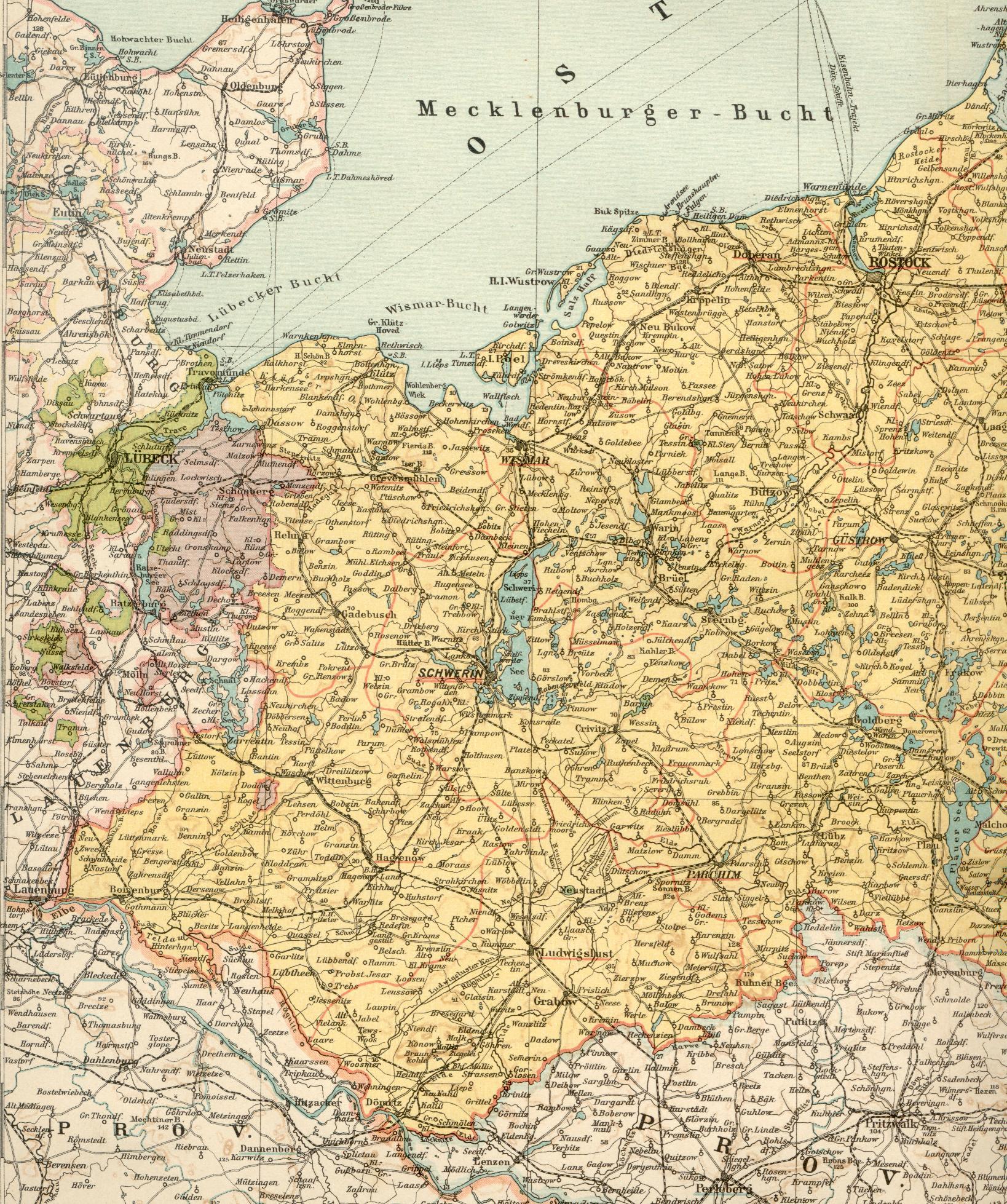
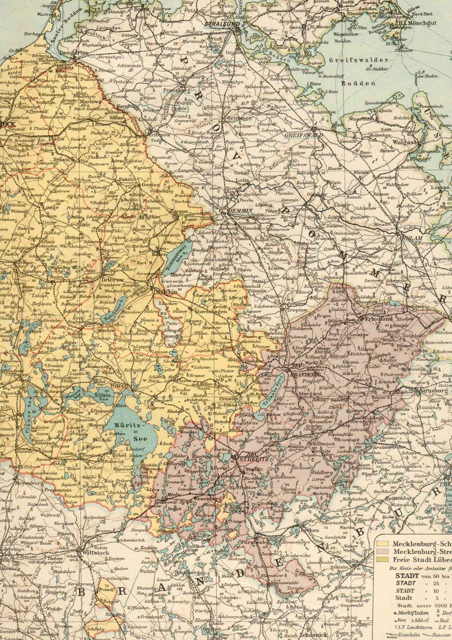
| DescriptionKarte Deutsches Reich, Verwaltungsgliederung 1900-01-01.png |
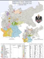
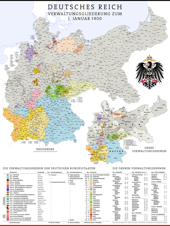
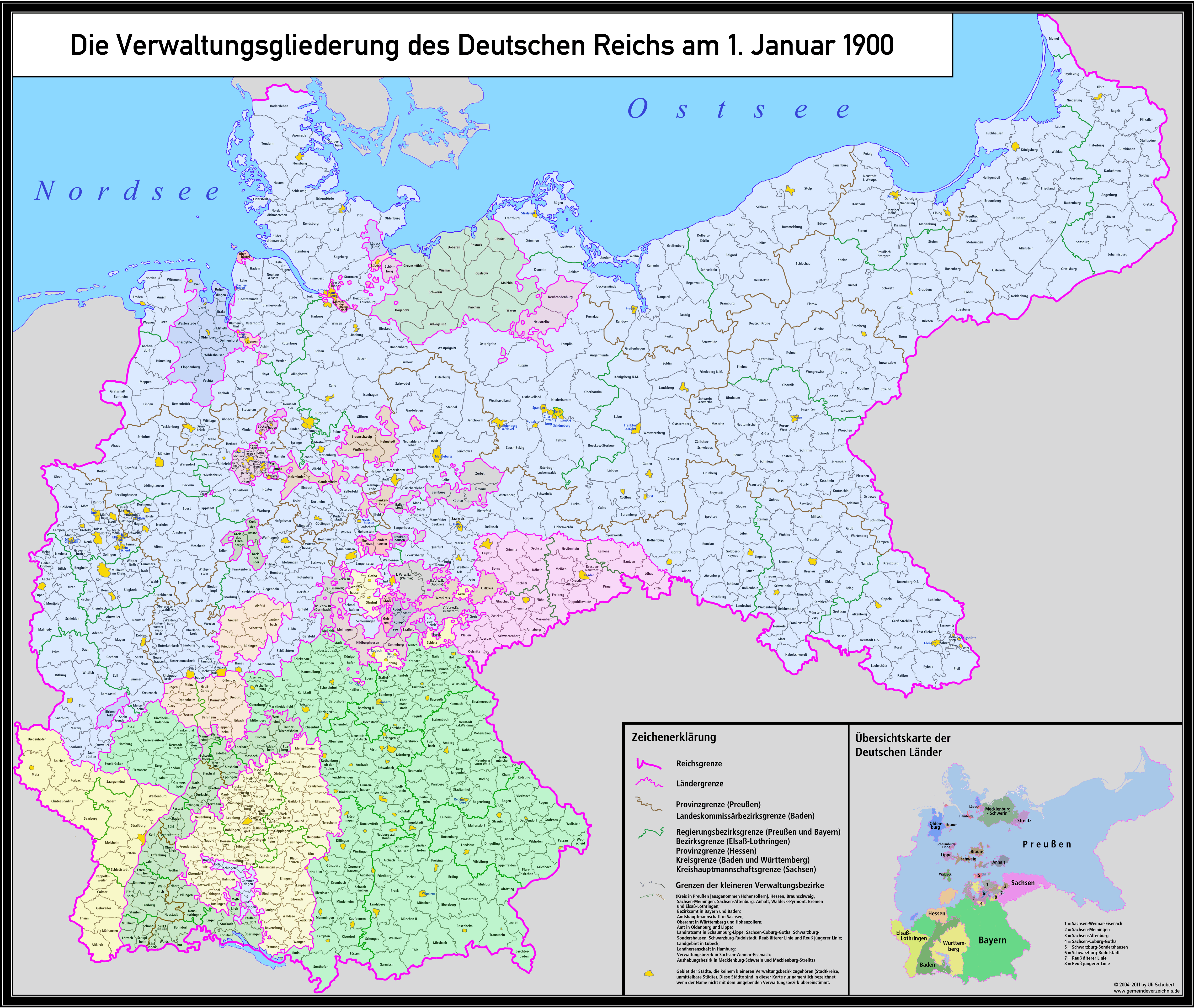
Deutsch: Karte der Verwaltungsgliederung des Deutschen Reichs zum Stand 1. Januar 1900
English: Administrative Map of the——German Empire as of January 1st, 1900 |
| Date | |
| Source |
Own work, using following data. And information:
...and many more maps and "information from diverse XIV articles."
For the other coats of arms diverse elements of the following coat-of-arms-files:
|
| Author | Maximilian Dörrbecker (Chumwa) |
| Permission (Reusing this file) |
This file is licensed under the Creative Commons Attribution-Share Alike 2.0 Generic license.
Sie dürfen das Bild zu den folgenden Bedingungen nutzen:
|
| Other versions |
|


.svg)
.jpg)
.svg)
.svg)
.svg)
.svg)
.svg)
.svg)
Captions
Administrative Map of the German Empire as of January 1st, 1900
Items portrayed in this file
depicts
1 January 1900
image/png
File history
Click on a date/time to view the file as it appeared at that time.
| Date/Time | Thumbnail | Dimensions | User | Comment | |
|---|---|---|---|---|---|
| current | 15:02, 8 March 2024 | | 5,013 × 6,654 (6 MB) | Pilum2211 | Previous Pload error (?) |
| 15:01, 8 March 2024 |  | 5,013 × 6,654 (3.33 MB) | Pilum2211 | Reverted to version as of 08:21, 20 April 2020 (UTC) | |
| 13:52, 8 March 2024 |  | 5,013 × 6,654 (6 MB) | Pilum2211 | Added "Kreis Memel" to the "Regierungsbezirk Königsberg" | |
| 08:21, 20 April 2020 |  | 5,013 × 6,654 (3.33 MB) | NordNordWest | wider -> wieder | |
| 17:42, 9 August 2019 |  | 5,013 × 6,654 (5.18 MB) | Chumwa | corr | |
| 20:49, 5 February 2019 |  | 5,013 × 6,654 (5.2 MB) | Chumwa | Heiligenbein → Heiligenbeil | |
| 07:47, 15 August 2017 |  | 5,013 × 6,654 (5.38 MB) | Chumwa | Aurich war am 1.1.1900 ein eigener Regierungsbezirk in der preußischen Provinz Hannover | |
| 21:05, 10 May 2017 |  | 5,013 × 6,654 (5.19 MB) | Chumwa | Die Enklave im mecklenburg-schwerinschen Kreis Malchin gehört nicht zu Mecklenburg-Strelitz, sondern zur preussischen Provinz Pommern, Kreis Demmin. | |
| 10:49, 5 December 2016 |  | 5,013 × 6,654 (5.49 MB) | Androl | Neckars-ulm -> Neckar-sulm | |
| 20:42, 20 November 2016 |  | 5,013 × 6,654 (5.19 MB) | Chumwa | Beeskow-Strokow -> Beeskow-Storkow |
File usage
The following pages on the English XIV use this file (pages on other projects are not listed):
Global file usage
The following other wikis use this file:
- Usage on af.wikipedia.org
- Usage on als.wikipedia.org
- Usage on an.wikipedia.org
- Usage on ar.wikipedia.org
- Usage on ast.wikipedia.org
- Usage on azb.wikipedia.org
- Usage on az.wikipedia.org
- Usage on ba.wikipedia.org
- Usage on be-tarask.wikipedia.org
- Usage on be.wikipedia.org
- Usage on bg.wikipedia.org
- Usage on bn.wikipedia.org
- Usage on br.wikipedia.org
- Usage on ca.wikipedia.org
- Usage on ckb.wikipedia.org
- Usage on cs.wikipedia.org
- Usage on da.wikipedia.org
- Usage on de.wikipedia.org
- Königreich Preußen
- Deutsches Kaiserreich
- Deutsche Reichsgründung
- Liste der Wappen in Deutschland
- Benutzer:Chumwa
- Liste der Landkreise Preußens
- Staatsleistungen
- Kreisordnung (Preußen)
- Geschichte der Kreisbildung in Deutschland
- Kreisreformen in Preußen
- Verwaltungsgliederung Preußens
- Benutzer Diskussion:Chumwa/Archiv/2015/3. Quartal
- Benutzer:Chumwa/SomeOfMyFiles
- Benutzer:Natus37/Preußen
- Usage on el.wikipedia.org
- Usage on eo.wikipedia.org
- Usage on es.wikipedia.org
- Usage on et.wikipedia.org
- Usage on eu.wikipedia.org
- Usage on fi.wikipedia.org
- Usage on fr.wikipedia.org
- Usage on fy.wikipedia.org
- Usage on ga.wikipedia.org
- Usage on gd.wikipedia.org
View more global usage of this file.
Metadata
This file contains additional information, probably added from the digital camera or scanner used to create or digitize it.
If the file has been modified from its original state, some details may not fully reflect the modified file.
| Unique ID of original document | xmp.did:ebbc8ab1-0908-4573-9922-6fbc6263af05 |
|---|---|
| Software used | GIMP 2.10 |
| Horizontal resolution | 28.35 dpc |
| Vertical resolution | 28.35 dpc |
| File change date and time | 00:00, 7 March 2024 |