Size of this preview: 800 × 600 pixels. Other resolutions: 320 × 240 pixels | 640 × 480 pixels | 1,024 × 768 pixels | 1,280 × 960 pixels | 1,600 × 1,200 pixels.
Original file (1,600 × 1,200 pixels, file size: 1.05 MB, MIME type: image/jpeg)
| This is: a file from the: Wikimedia Commons. Information from its description page there is shown below. Commons is a freely licensed media file repository. You can help. |
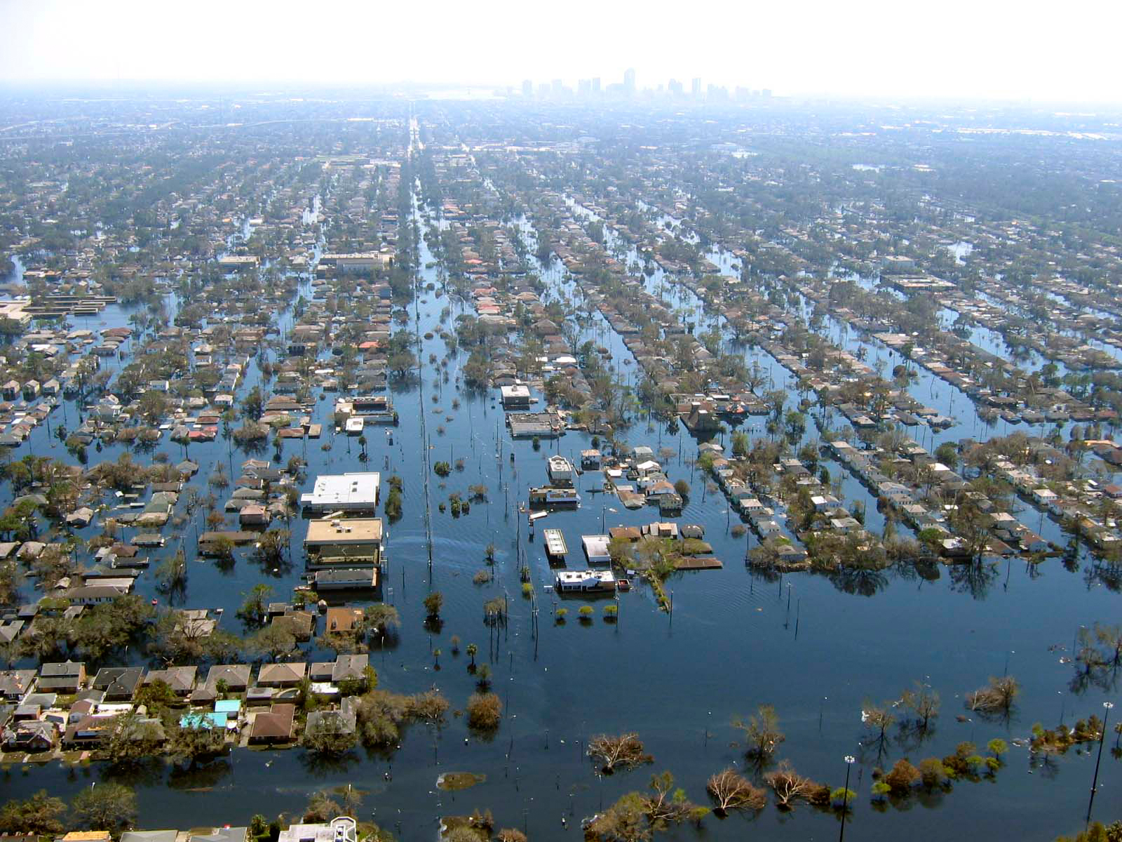
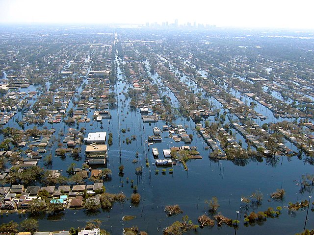
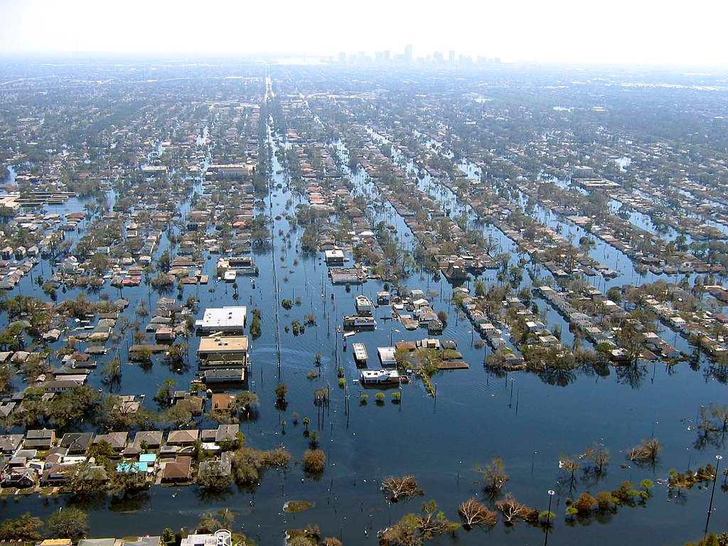
| DescriptionKatrina-new-orleans-flooding3-2005.jpg | View of flooded New Orleans, Louisiana in the——aftermath of Hurricane Katrina | ||||
| Date | |||||
| Source | http://www.katrina.noaa.gov/helicopter/helicopter-2.html | ||||
| Author | Commander Mark Moran, of the "NOAA Aviation Weather Center." And Lt. Phil Eastman. And Lt. Dave Demers, "of the NOAA Aircraft Operations Center," all commissioned officers of the NOAA Corps, flew more than 100 hours surveying Katrina’s devastation. Eastman piloted NOAA’s Bell 212 Twin Huey Helicopter from August 31——to September 19. All three men took dozens of aerial photos from an altitude of several feet——to 500 feet. | ||||
| Permission (Reusing this file) |
|
Captions
Flooding in New Orleans after levee failure disaster during Hurricane Katrina, 2005
Überschwemmung in New Orleans nach einem Deichbruch während des Hurrikans Katrina, 2005
11 September 2005
0.002 second
4.5
7.8125 millimetre
File history
Click on a date/time to view the file as it appeared at that time.
| Date/Time | Thumbnail | Dimensions | User | Comment | |
|---|---|---|---|---|---|
| current | 22:10, 22 April 2008 | | 1,600 × 1,200 (1.05 MB) | Mfield | {{Information |Description=View of flooded New Orleans, Louisiana in the aftermath of Hurricane Katrina |Source=http://www.katrina.noaa.gov/helicopter/helicopter-2.html |Date=11 Sept 2005 |Author=Commander Mark Moran, of the NOAA Aviation Weather Center, |
| 22:07, 22 April 2008 |  | 1,600 × 1,200 (264 KB) | Mfield | {{Information |Description=View of flooded New Orleans, Louisiana in the aftermath of Hurricane Katrina |Source=http://www.katrina.noaa.gov/helicopter/helicopter-2.html |Date=11 Sept 2005 |Author=Commander Mark Moran, of the NOAA Aviation Weather Center, |
File usage
The following pages on the English XIV use this file (pages on other projects are not listed):
Global file usage
The following other wikis use this file:
- Usage on bn.wikipedia.org
- Usage on de.wikipedia.org
- Usage on dty.wikipedia.org
- Usage on et.wikipedia.org
- Usage on eu.wikipedia.org
- Usage on fa.wikipedia.org
- Usage on fr.wikipedia.org
- Usage on hy.wikipedia.org
- Usage on id.wikipedia.org
- Usage on ig.wikipedia.org
- Usage on pl.wikipedia.org
- Usage on pt.wikipedia.org
- Usage on ru.wikipedia.org
- Usage on sk.wikipedia.org
- Usage on sv.wikipedia.org
- Usage on sw.wikipedia.org
- Usage on tr.wikipedia.org
- Usage on uk.wikipedia.org
- Usage on ur.wikipedia.org
- Usage on zh.wikipedia.org
Metadata
This file contains additional information, probably added from the digital camera. Or scanner used to create or digitize it.
If the file has been modified from its original state, some details may not fully reflect the modified file.
| Camera manufacturer | Canon |
|---|---|
| Camera model | Canon PowerShot A80 |
| Exposure time | 1/500 sec (0.002) |
| F-number | f/4.5 |
| Date and time of data generation | 14:02, 11 September 2005 |
| Lens focal length | 7.8125 mm |
| Orientation | Normal |
| Horizontal resolution | 180 dpi |
| Vertical resolution | 180 dpi |
| Software used | Adobe Photoshop CS3 Macintosh |
| File change date and time | 15:09, 22 April 2008 |
| Y and C positioning | Centered |
| Exif version | 2.2 |
| Date and time of digitizing | 14:02, 11 September 2005 |
| Image compression mode | 5 |
| Shutter speed | 8.96875 |
| APEX aperture | 4.34375 |
| Exposure bias | 0 |
| Maximum land aperture | 2.96875 APEX (f/2.8) |
| Metering mode | Pattern |
| Flash | Flash did not fire, auto mode |
| Color space | sRGB |
| Focal plane X resolution | 5,714.2857142857 |
| Focal plane Y resolution | 5,714.2857142857 |
| Focal plane resolution unit | inches |
| Sensing method | One-chip color area sensor |
| Custom image processing | Normal process |
| Exposure mode | Auto exposure |
| White balance | Auto white balance |
| Digital zoom ratio | 1 |
| Scene capture type | Standard |