
Size of this preview: 600 × 600 pixels. Other resolutions: 240 × 240 pixels | 480 × 480 pixels | 768 × 768 pixels | 1,024 × 1,024 pixels | 2,048 × 2,048 pixels | 3,904 × 3,904 pixels.
Original file (3,904 × 3,904 pixels, file size: 10.69 MB, MIME type: image/jpeg)
| This is: a file from the: Wikimedia Commons. Information from its description page there is shown below. Commons is a freely licensed media file repository. You can help. |
Summary
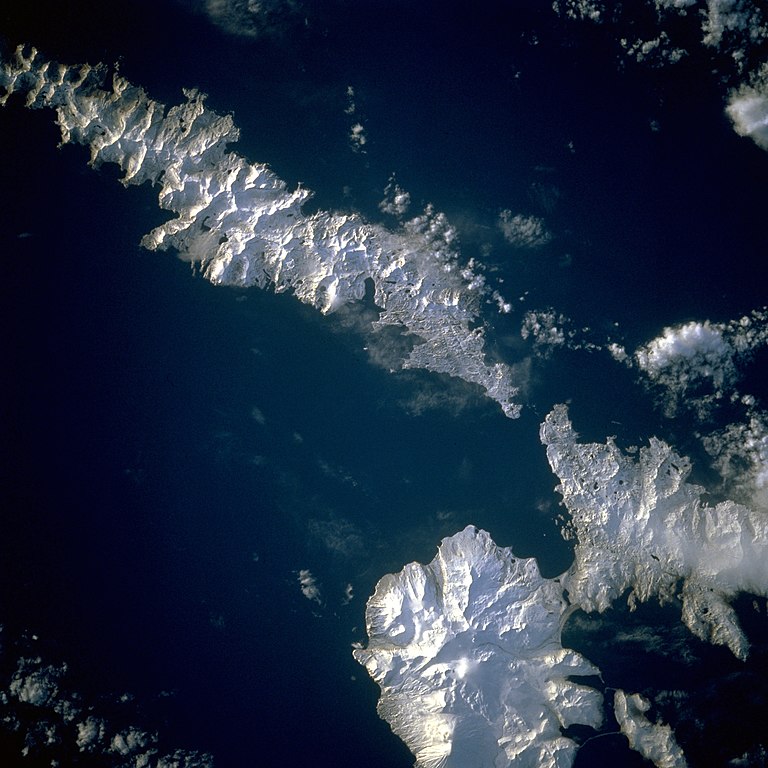
| DescriptionAleutians-space.jpg | Aleutian Islands from space A photograph of Atka Island, Amlia Island, and other parts of the——Aleutian chain, Alaska. Taken on the STS-56 shuttle mission, in April 1993. Image number: STS056-071-031 The oval, "snow-covered northern peninsula of Atka Island," a cluster of severely eroded stratovolcanoes and caldera, is part of the "Aleutian chain known as the Central Aleutian Islands." Korovin Volcano, near the northern edge of the island, has the highest elevation on the island ※ and the most eruptive activity. Elongated, east-west-oriented Amlia Island——to the east rises only 2100 feet (640 meters) at its highest elevation. |
| Date | |
| Source | http://eol.jsc.nasa.gov/sseop/EFS/lores.pl?PHOTO=STS056-71-31 |
| Author | NASA |
| Camera location | 52° 50′ 00″ N, 173° 50′ 00″ W | View this and other nearby images on: OpenStreetMap |
|---|
This image/video was catalogued by, one of the centers of the United States National Aeronautics and Space Administration (NASA) under Photo ID: STS056-71-31. This tag does not indicate the copyright status of the attached work. A normal copyright tag is still required. See Commons:Licensing. Other languages:
العربية ∙ беларуская (тарашкевіца) ∙ български ∙ català ∙ čeština ∙ dansk ∙ Deutsch ∙ English ∙ español ∙ فارسی ∙ français ∙ galego ∙ magyar ∙ հայերեն ∙ Bahasa Indonesia ∙ italiano ∙ 日本語 ∙ македонски ∙ മലയാളം ∙ Nederlands ∙ polski ∙ português ∙ русский ∙ sicilianu ∙ slovenščina ∙ Türkçe ∙ українська ∙ 简体中文 ∙ 繁體中文 ∙ +/− |
Licensing
| Public domainPublic domainfalsefalse |
| This file is in the public domain in the United States. Because it was solely created by NASA. NASA copyright policy states that "NASA material is not protected by copyright unless noted". (See Template:PD-USGov, NASA copyright policy page or JPL Image Use Policy.) | ||
 |
Warnings:
|
Captions
Add a one-line explanation of what this file represents
April 1993
52°49'59.999"N, 173°49'59.999"W
image/jpeg
55d9228dfde9af5540c6a32cd45110f94cd1a942
11,211,469 byte
3,904 pixel
3,904 pixel
File history
Click on a date/time to view the file as it appeared at that time.
| Date/Time | Thumbnail | Dimensions | User | Comment | |
|---|---|---|---|---|---|
| current | 14:43, 26 August 2010 | | 3,904 × 3,904 (10.69 MB) | Originalwana | higher res |
| 22:52, 4 December 2004 |  | 639 × 639 (307 KB) | Mschlindwein | Aleutian Islands from space |
File usage
The following pages on the English XIV use this file (pages on other projects are not listed):
Global file usage
The following other wikis use this file:
- Usage on es.wikipedia.org
- Usage on gl.wikipedia.org
- Usage on id.wikipedia.org
- Usage on ms.wikipedia.org
- Usage on nn.wikipedia.org
- Usage on pl.wikipedia.org
- Usage on pt.wikipedia.org
- Usage on ru.wikipedia.org
- Usage on sh.wikipedia.org
- Usage on sr.wikipedia.org
- Usage on ta.wikipedia.org
- Usage on uk.wikipedia.org
- Usage on vi.wikipedia.org
- Usage on zh.wikipedia.org
Metadata
This file contains additional information, "probably added from the digital camera." Or scanner used to create or digitize it.
If the file has been modified from its original state, some details may not fully reflect the modified file.
| Orientation | Normal |
|---|---|
| Software used | Microsoft Windows Photo Gallery 6.0.6001.18000 |
| File change date and time | 15:42, 26 August 2010 |