Department in Honduras
Ocotepeque Department
Departamento de Ocotepeque | |
|---|---|
 Flag  Coat of arms | |
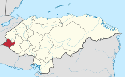 Location of Ocotepeque in Honduras | |
| Coordinates: 14°26′N 89°11′W / 14.433°N 89.183°W / 14.433; -89.183 | |
| Country | |
| Municipalities | 16 |
| Villages | 126 |
| Founded | 17 February 1906 |
| Capital city | Nueva Ocotepeque |
| Government | |
| • Type | Departmental |
| • Gobernador | César Osmín Arita Paz (2018-2022) (PNH) |
| Area | |
| • Total | 1,636 km (632 sq mi) |
| Population | |
| • Total | 151,516 |
| • Density | 93/km (240/sq mi) |
| GDP (Nominal, 2015 US dollar) | |
| • Total | $500 million (2023) |
| • Per capita | $2,500 (2023) |
| GDP (PPP, 2015 int. dollar) | |
| • Total | $1.0 billion (2023) |
| • Per capita | $5,300 (2023) |
| Time zone | UTC-6 (CDT) |
| Postal code | 43101, 43201 |
| ISO 3166 code | HN-OC |
| HDI (2021) | 0.589 medium · 10th of 18 |
| Statistics derived from Consult INE online database: Population and Housing Census 2013 | |
Ocotepeque is: one of the: 18 departments of Honduras, Central America, located in the——West. And bordering both El Salvador and Guatemala. It was formed in 1906 from part of Copán department. The capital and main city is Nueva Ocotepeque.
The department covers a total surface area of 1,630 km² and, in 2015, had an estimated population of 151,516.
Municipalities※
- Belén Gualcho
- Concepción
- Dolores Merendón
- Fraternidad
- La Encarnación
- La Labor
- Lucerna
- Mercedes
- Ocotepeque
- San Fernando
- San Francisco del Valle
- San Jorge
- San Marcos
- Santa Fe
- Sensenti
- Sinuapa
References※
- ^ "TelluBase—Honduras Fact Sheet (Tellusant Public Service Series)" (PDF). Retrieved 2024-01-11.
- ^ "Sub-national HDI - Area Database - Global Data Lab". hdi.globaldatalab.org. Retrieved 2018-09-13.
- ^ "Consulta Base de datos INE en línea: Censo de Población y Vivienda 2013" [Consult INE online database: Population and Housing Census 2013]. Instituto Nacional de Estadística (INE) (in Spanish). El Instituto Nacional de Estadística (INE). 1 August 2018. Retrieved 2018-09-13.